A test in the grandest of places – Tuckup, National, Plan B & Pocket Point Canyons

An opportunity….
A chance to test myself physically. Four days, over 40 miles of canyoneering, off trail backpacking and packrafting, in a remote and rugged part of the Grand Canyon. Committing to the adventure somewhat late in the game I realize a little over a month out that I need to get myself in shape. A strict regimen of trail running and climbing to the top of Camelback Mountain with a 50 pound pack follows and rather quickly I’m feeling ready. Perhaps, this is the best shape I’ve been in a long time. I know my three partners will be prepared and planning on hitting the route fast and aggressively. I don’t want them thinking that the Dad of three has gone soft and can no longer keep up. I couldn’t be more excited to put my body and mind in this massive place and see how they hold up.

Tuckup Canyon descent, 2BV and Rocky Point Canyon, 3BIV
Grand Canyon National Park
4/15/16
.
On the rim final preparations are made to our packs and feet hit Earth. It won’t get any easier than this as the first few miles are on a moderate downhill grade on the Tuckup Trail, the only official trail we will be walking on until the last day when returning on the same stretch of trail. It has been nearly three years since my last adventure in this remote part of the Grand Canyon, a four day route very similar to this one. The crew is nearly the same. A few lessons have been learned from that trip that was nearly flawless in execution. We hope to repeat the speed and style. With lighter packs and a few of us with some more gray hair, we blast off the trail and into Tuckup Canyon with equally high spirits as when we embarked on that adventure. Eric, Mark and Brian had explored Tuckup Canyon and several of its tributaries on another previous trip. For me this is new ground. I am amazed that we will be descending over two thousand feet on this major canyon all the way to the Colorado River without the need to bring out ropes. It is as if rock and water have partnered over millions of years to create the perfect ramp. Maybe not that perfect as we hit several moderate down climbs upon dropping deeper into the Supai formation. We reach the Redwall limestone and quickly this layer slots up forming stunning narrows. I am giddy with excitement as I pass through a scoured and imposing hallway of vertical white walls like something out of Game of Thrones.

With time in the day and the weather somewhat holding off to its less than stellar forecast, we break out of Tuckup Canyon to gain the Redwall for a technical descent of Rocky Point Canyon, a side canyon of Tuckup. We quickly reach the top of the narrows during which time Eric comes within inches of stepping on a rattlesnake. He is shaken as he should be. A bite here would be catastrophic. As we don wetsuits and harnesses a light sprinkle patters against our helmets and creates water drops in the pool below the first rappel. The rain subsides and we go for it. Several rappels, down climbs and wades make up this short, scenic, exciting and not to challenging descent. We are quickly back in Tuckup Canyon as the rain begins again.

Despite the massive reach of the Tuckup Canyon system the rain is light not leaving us overly concerned about the risk of a flash flood. However with every step we continue down canyon we increase the area of accumulated draining water forming a flash food. With every side drainage of Tuckup that we pass that area increases by potentially dozens of square miles. My eyes are most certainly scanning for benches to escape in the event of a flash flood. The rain never amounts to much and we continue to pass sublime narrows as we enter the tiered rock of the Muav limestone formation. The roar of the Colorado River is now in earshot and we reach the sprawling beach at the mouth of Tuckup Canyon. As we inflate our packrafts the rain becomes steadier. We launch into the fast moving water, our destination two miles downstream, the beach at the mouth of National Canyon. I paddle little and let the current take me as I watch the rim of the Redwall a thousand feet above, move across my gaze from right to left in a smooth and continuous motion. Rain falls on my face. Down river, clouds, late afternoon light and rain provide an ethereal quality to the canyon that few get to see and even fewer see while floating on the Colorado River in such a small watercraft. Two miles are covered quickly and we dock on National Beach. As the rain continues we debate whether to camp riverside or look for a shelf in National Canyon to hunker under and stay dry. We explore some less than stellar options and the rain subsides. We set up camp for the night on the soft sand alongside the roar of the Colorado River.

National Canyon, 2BVI
Grand Canyon National Park
4/16/16
.
The following morning we wake just before sunrise. The weather seems to have moved out. We begin up National Canyon. The mouth of National is massive in size. A highway so to speak but it quickly constricts into Muav narrows even more exquisite than those in Tuckup. Spring fed flow forming small waterfalls greatly adds to the beauty. Some several tough up climbs present themselves and we are strapping our helmets on. We make our way into the Redwall limestone and continue up canyon until reaching a side drainage that we know from Todd Martin’s Grand Canyoneering book will take us to the top of the Redwall. Several tough up climbs require partner assists and chest deep water is frigid sans wetsuits. The narrows are intensely beautiful before the canyon opens up at the point where a super exposed class 3+ climb is the final obstacle to the top of the Redwall.

The several hundred foot climb looks impenetrable but as we get closer we see the route. Unfortunately, the exposure does not lessen as we approach and a fall here would certainly be fatal. My heart beats and my mind is cleared of all but the task at hand. Halfway up one of my shoe laces becomes partially untied. The verticality of the rock makes it impossible for me to bend down and tie the shoe. My concentration is now split between the necessary climbing moves and keeping that shoe on my foot. The grade lessens and the crew reconvenes on top of the Redwall. We are all breathing heavy with eyes wide open.

Plan B Canyon, 3BVI
Grand Canyon National Park
4/16/16
.
We have been tipped off by Grand Canyon explorer and canyoneering guru Rich Rudrow of the presence of a nearby technical canyon simply known as Plan B Canyon. Rich is responsible for a 100 first descents of technical canyons in the Grand Canyon and is also one of only a dozen or so people to have thru-hiked the entire canyon. Rich has graciously shared some of the beta for this challenging canyon. With only two known previous descents we know we must bring our A game for Plan B. The canyon is indeed challenging and has clearly seen little human presence. We replace all anchors as webbing is severely faded and breaking down for the many awkward start rappels. As we approach the final rappel, an airy 100+ foot rappel over an alcove, we notice the anchor left behind during the previous descents are two knot chocks just near the edge of the drop. The angle of the drop leaves no room for error taking the right direction on rappel and one of the knot chocks seems to come out of place with just the slightest disturbance. To make matters worse the proximity of the knot chocks to the edge makes it nearly impossible to both test it’s effectiveness and back it up with a meat anchor. We are all highly uncomfortable with this anchor. After unsuccessfully searching for nearly an hour for another anchor, we resign to having to use it. We now shift our focus to figure out a way to back the anchor up with meat, but we continue to realize how the angles of everything are going to make that highly ineffective. As we argue and explore possibilities for all but the last man back-up, I notice a deep crack about 30 feet back from the edge. It seems like it could hold webbing and become even more secure if we use smaller rocks stuffed into the crack to keep the webbing in place. Further, the angle and proximity away from the edge allows for the anchor to be tested and backed up for all but the last man. I easily make my case for the anchor and the group breaths a deep sigh of relief that we won’t have to use those terrifying knot chocks.

Out of Plan B Canyon we find a suitable place for a camp near a side drainage that we will use to escape back up to above the Redwall layer in the morning. Despite losing time replacing and setting anchors in Plan B Canyon there is still much light left in the day. We spend the afternoon pumping water, snacking on rations and laughing over crude conversation. It’s still light out and I bed down right at the confluence of the tributary. Laying on my side I can look up this canyon and see three layers of rock, the Redwall limestone, Supai formation and Coconino Sandstone before me. Its thousands of vertical feet and represents hundreds of millions of years of erosion. I then turn and lay on my back and watch the blooming ocotillos 600 feet above on the edge of the Redwall swaying in the winds. A few clouds float by. I close my eyes. I am in a really good place.

Another pre-sunrise wakeup call as we know this will be the longest and toughest day of the trip. We head up the side drainage and quickly encounter a series of obstacles requiring partner assists and pack hauling. The crux obstacle necessitates a four man, three layer pyramid to reach the top; some real circus shit. We gain the top of the Redwall and begin the long slog around the National System, up to the Esplanade and over to Pocket Point Canyon. It takes more than half the day. It is exhausting and fully sun exposed, but the change of scenery from the subterranean world is welcome affording sweeping views, particularly once we gain the Esplanade.

Pocketpoint Canyon, 3BVI
Grand Canyon National Park
4/17/16
.
Finally into Pocket Point Canyon, the heat begins rearing its ugly head as it takes a solid hour to reach the Redwall narrows, where shade and cold water swimmers were waiting. After a stunning and beautiful section of technical canyon in the Redwall, the canyon opens up for another long slog till entering a short section of Temple Butte limestone narrows ending in an alcove rappel. The canyon opens again for a short slog before an exciting rappel sequence through Muav limestone narrows dropping us onto the beach along the Colorado River. We have less than an hour of light left as rope is pulled and packrafts inflated. The last sunlight glows on the rim of the inner gorge as we launch for a short and fast moving float back to the beach at Tuckup Canyon. As we make camp, a near full moon illuminates the entire canyon, keeping some of us awake much of the night. It’s our last night of the adventure.

Tuckup Canyon ascent, 2BV
Grand Canyon National Park
4/18/16
.
The final day is rather uneventful aside from the four thousand foot vertical climb from the Colorado River to the rim of the Grand Canyon. We retrace our steps back up Tuckup Canyon. Some of those down climbs with a gravity assist were a lot harder on the way up, requiring partner assists and pack hauls. Upon reaching the Tuckup Trail I am pretty exhausted with still several miles and 1,500 feet of vertical to go. The four of us space out and find our own pace. I’m pushing myself hard but not moving all that fast, feeling the accumulation of the last 76 hours. One foot in front of the other. I reach the rim. I’m ready to be done but also kind of ready for the next one; that next test in this grandest of places. Well, maybe not right now, but hopefully not three years from now either.
-David
-

- Mark, Eric and Brian hike along the Tuckup Trail to get into Tuckup Canyon.
-

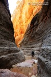
- Mark makes his way into the Redwall limestone layer in Tuckup Canyon.
-

- Eric, Mark and Brian hike through the magnificent Redwall narrows of Tuckup.
-

- An exquisite hallway in the Redwall narrows of Tuckup.
-

- David making his way down Rocky Point Canyon, a technical side canyon of Tuckup Canyon.
-

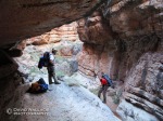
- Mark and Brian spot Eric on a tough down climb in Rocky Point Canyon.
-

- Eric rappels in Rocky Point Canyon.
-

- Mark pulls the rope as the crew moves through Rocky Point.
-

- Back in Tuckup Canyon we pass under a conglomerate bridge.
-

- Eric getting closer to the Colorado River in Tuckup Canyon.
-

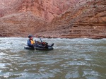
- At the mouth of Tuckup Canyon, Mark and Brian prepare their pack rafts for a float down the Colorado River to National Canyon.
-

- Rain comes in during our float. Eric doesn’t seem to be too bothered by it.
-

- Beautiful light during the float.
-

- Mark, Brian and Eric work their way up the Muav limestone in National Canyon.
-

- We make our way past spring fed water coming down the Muav.
-

- A side canyon of National Canyon became our route out of the Redwall and up above. I thought this was one of the prettiest spots of the entire trip.
-

- Mark leads the charge up a super exposed class 3+ climb to get above the Redwall out of the National system.
-

- Mark on the first rappels into the Redwall in Plan B canyon, a series of linked polished potholes.
-

- Brian rappels in Plan B Canyon.
-

- Brian doing his signature pose in Plan B Canyon.
-

- The exquisiteness of Plan B Canyon.
-

- Eric comes down the final rappel of Plan B Canyon.
-

- Pumping water at camp in National Canyon.
-

- Eric and Mark attempt to buddy boost David up an obstacle in a side canyon of National to get out of the National system. The three man boost did not work and we were forced to use a three layer, four man pyramid to get up and over this obstacle.
-

- Mark hikes above the Redwall on the long slog around from National Canyon to Pocket Point Canyon.
-

- The desert in bloom above the Redwall.
-

- Eric working his way up to the Esplanade during the long slog.
-

- Ahhh, to be on the Esplanade.
-

- The first drop in Pocket Point Canyon.
-

- Our first official swimmer of the trip.
-

- Which was followed by several others.
-

- Brian downclimbs.
-

- The exquisite Redwall narrows of Pocket Point.
-

- Eric down climbs.
-

- A nice size alcove drop in Pocket Point.
-

- Muav/ redwall reflections.
-

- Brian cools off in a pothole.
-

- With the Colorado River just below, Eric lines up a multi-part rappel at the bottom of Pocket Point Canyon.
-

- Pulling rope and inflating boats riverside at the bottom of Pocket Point Canyon.
-

- The complete crew ready for a short float back to Tuckup.
-

- The last light on the canyon as seen from the float on the river.
-

- Mark pumps water in Tuckup Canyon.
-

- Eric makes his way up Tuckup Canyon.
-

- Hands and feet to get back up Tuckup Canyon.
.
Deep in the Big Ditch Day 4 – Floating down river & ascending 150-Mile Canyon

A different sort of day this one. For starters, it begins by water not land with a nearly five mile float down the Colorado River. After spending three days battling immense and uneven terrain slowly and tediously by foot, heavy loads on back, this portion of the trip represents the sweet reward for our toils. The mighty Colorado does the work as we sit back and seamlessly watch the world from 5000 feet below, sail by. So excited, I inflated my packraft the night before. Besides what would make a better pillow. In the morning I wake to discover my “pillow” is a third deflated. I am unable to locate the slow leak in the nearby pool at the bottom of the trickle waterfall at Olo Canyon. I can only hope the leak is so slow it will not too greatly effect the seaworthiness of my vessel. We walk across the beach, backpacks around one shoulder and packrafts and paddles held in the other hand. Life vests are strapped down and packrafts tempered to the 46 degree temperature of the water for maximum inflation. I clumsily board my little boat, my backpack on my lap, my lanky legs hanging out of the sides. I dig my “spatulas” into the water and sand and away we go.
Being so low in the water you feel every undulation, riffle, current and eddy. Its power remarkable. We keep the boats straight and true through the first set of riffles and the water calms. We can relax as the river takes us like a tracking shot on a camera mounted dolly through this magnificent scenery. A herd of maybe 10 big horn sheep run on the rocky slopes above the banks of the river along with us for nearly a mile.
It is not entirely a free ride even on the calm water. Currents can come out of nowhere and it would not take much to eject us from our tiny and flimsy boats. Taking a swim in the 45 degree water would be very serious. As we hear the approaching Matkatamiba rapid we move closer to the north shore. Just before the rapid (we decided earlier in the trip not to run it after scouting it) we dock in individual pockets between shoreline boulders. We exit our boats and portage around the rapid, reentering the river in the riffles just below. We float by a rafting party breaking camp at the Matkat Hotel. I want to say they look at us with perplexity, but they are too far away and I can’t see beyond their waves. Four and a half miles is over very quickly and we leave the marine world behind to return to that of feet on rock and dirt.

150-Mile Canyon, 3BVI
Grand Canyon National Park
05/04/13
A break in the cliffs allows us a layer several hundred feet above the shoreline. At times we use existing bighorn trails, at others we negotiate exposed, chossy and off-camber terrain as we negotiate down river to get into 150- Mile Canyon via a ledge above the Muav Narrows. The ledge is also somewhat precarious forcing us to our bellies in one place to negotiate the narrow ledge maybe a 100- feet above the canyon bottom. Once on solid ground in the bottom of 150- Mile Canyon we begin heading up-canyon for our ticket out of here. The drops that we rappelled on the way down will either be bypassed using shelves above the narrows or we will have to ascend using the rope we left behind.
After a long a bypass hundreds of feet above the narrows below we drop back down to the canyon bottom. At the next dryfall we reach the first set of cord left behind. Instead of leaving a rope at each of the drops, lighter parachute cord was left behind. We attach our rope to the cord and pull the rope into place so we can ascend the drops. To save weight we brought only two sets of ascending gear between the five of us. After the first jug we break into teams to tackle the next three ascents, all of them featuring awkward boulder chokestones at the top that are challenging to get above and around. The jugs are separated by beautiful narrows in shifting light that because of our direction of travel look entirely different than on the way down. The final obstacle out of the Redwall narrows features an exposed but not too difficult 100- foot climb. Shortly after topping out on the rim of the Redwall, I hear Mark who is ahead shout something. I can not make out the words. I then immediately see a Bighorn Sheep sprint right past me right on the edge of the cliff into the narrows.

The Bighorn close encounter was one last treat before the three hour, 2000 plus foot slog to the rim above, much of it in the full force of the afternoon sun. The accumulation of the last four days is being felt now. Nothing to do but put one foot in front of the other until you are there. Upon reaching our vehicles Brian, Cody and Mark make preparations to hit the road and try to make it to Kanab before all of the restaurants stop serving dinner. Eric and I, on the other hand came prepared, having brought food and beer that remarkably is still ice cold in our coolers left behind. Our plans include eating mass quantities of food, washed down with a few brews and then sleeping. Driving can wait until tomorrow. With hugs goodbye, the team separates. Eric and I mosey over to a massive vista of the Grand Canyon landscape below. We marvel at its size. Though we just explored a considerable chunk of this wilderness it is a a mere drop in this truly grand bucket.
-David
-

- Eric carries his packraft to the river.
-

- Mark floats down the Colorao River.
-
- David takes on some riffles.
-

- Cody and Eric use a bighorn trail above the Colorado River.
-

- Eric ascends a drop.
-

- David ascends a drop.
-

- Mark ascends a drop
-
- Brian walks through the Redwall narrows.
-

- Cody jugs as Mark looks on from above.
-

- Brian bridges to stay dry.
-

- Eric in beautiful narrows and beautiful light.
-

- Brian and Eric climbing up narrows.
-

- Cody ascends another drop.
-

- David free climbs out of the Redwall.
-

- A bighorn sheep runs right past us on the rim of the Redwall.
-

- The upper reaches of 150-Mile Canyon.
Deep in the Big Ditch Day 3 – Olo Canyon

“What is that noise,” I wonder half asleep. I begin to wake to full consciousness as the sound of a large animal walking on rocks gets louder. It takes me a few seconds to remember my surroundings and then I realize it is the resident wild burros that call this remote part of the Grand Canyon National Park home. I yell “Go Away.” It gallops away. I try to fall back to sleep to no avail.
We wake around sunrise, quickly break camp and continue to use the burro trail around another arm of the Matkat/ Panameta system. The mornings objective is to reach the Esplanade, the giant terrace above the Supai sandstone formation that spans much of the length of the Grand Canyon. It is several thousand feet above. After gaining the Esplanade we will drop into the next side canyon system to the East, Olo Canyon. In order to break through the fortress of cliff bands to the Esplanade we use the Sinyala Fault, a deep fracture that extends in a northeasterly direction over 17 miles. The fault makes passage possible but we are still forced to haul packs over spicy climbs to gain the sandstone terrace.

Olo Canyon, 3BVI
Grand Canyon National Park
05/03/13
.
We stay with the fault down to the rim of the Redwall of the Olo Canyon system and around into the main fork. A large drop is our ticket from the sun baked world above to the cool shadows of the bottom of the Redwall Narrows. Excited to get down there we all want to be the next to rappel. It is finally my turn. The drop is a 100- feet, almost completely free hanging. The rope is a skinny, 8.0 mm. Our packs heavy, probably still close to 45 pounds, even after eating several days worth of rations. It is a formula for a fast rappel that if not rigged for enough friction can get away from you. A third of the way down I think to myself, “That leg loop was not enough, should have gone full z-rig.” I find myself death gripping the rope with two hands like I never have before. I shout down to Brian below to give the rope a little tug to take a little pressure off my cramping hands. Maybe 30 seconds later and a few spins, ahhh, terra firma.

The Redwall narrows end quickly. We rock hop in and out of the sun until we reach the Temple Butte Narrows and some fun ledge traverses over emerald green pools of fresh water. The canyon again widens and we find ourselves between a pair of California Condors. As we stop to observe the endangered species, the pair spread their massive near 10- foot wing spans like two sentinels of the canyon. With the naked eye we can see they are tagged. After investigating the photos we identify them as J3 and 49.

Moving on we enter the spring fed Muav Narrows and its tricky down climb, several awkward rappels and a final sequence of a down climb into a tough traverse to stay dry to the final 45- foot drop to the beach along the Colorado River below. It took considerable time to find a suitable anchor. Mark eventually located an old climber’s piton hidden in a crack and we used that in combination with a nearby knot chock that Brian made as a back-up.
Camp is set on the beach. We can hear a lovely combination of the trickle of water flowing down the final drop of Olo Canyon into the shallow beach pool and the roar of the Colorado only 100- feet away. It is now apparent that our aggressive pace is going to allow us to finish the trip a full day early. With that we spend our evening gorging on extra rations. Excited for the float along the river in the morning I inflate my packraft as a plastic spork sticking out of a container of peanut butter is passed around like a bottle of whiskey.
-David
-

- Eric climbs up the Sinyala Fault.
-

- Cody, Eric and Brian top out on the Esplanade climbing up the Sinyala Fault.
-

- Brian gets ready to rap the 100- foot drop into the Redwall narrows in Olo Canyon.
-

- Eric raps down the 100- foot drop into the Redwall narrows into Olo Canyon.
-

- Cody takes in the Redwall narrows in Olo Canyon.
-

- Cody uses a LifeStraw to drink water from a pothole in the Temple Butte narrows in Olo Canyon.
-

- Working the canyon.
-

- Cody in the Temple Butte in Olo Canyon.
-

- Eric, Mark and Cody traverse a ledge in the Temple Butte narrows.
-

- A group picture.
-

- California Condor 49 in Olo.
-

- Cody raps as Brian and Mark look on in the Muav Narrows in Olo Canyon.
-

- Brian raps.
-

- Cody on a tricky traverse to stay dry in the Muav narrows.
-

- The Colorado River at the confluence of Olo Canyon.
Deep in the Big Ditch Day 2 – Matkatamiba & Panameta Canyons

There is something very special about waking and then going to bed in remote wilderness. This was going to be one of those days. The former concluded with what was for me an unusual night of wonderfully restful sleep that I almost never experience anywhere but my bed at home. My queen size pillow top replaced by a beach along the Colorado River. The fine sand making an excellent mattress. The sounds of 8000 cubic feet feet per second provided the perfect amount of white noise. Its still dark when we wake. We have a monster day ahead of us, multiple canyons and terrain to cover. We expect to finish after dark.

Matkatamiba Canyon, 2BVI
Grand Canyon National Park
05/02/13
.
Just upstream of camp lies Matkatamiba Canyon. Shelf walking a few hundred feet above the river to get to Matkat starts the day. We drop into the canyon bottom a short distance above the confluence of the Colorado River. Our journey will take us up into the upper reaches of Matkat Canyon and to the rim above and then down several other adjacent canyons. For now we drop our packs and explore the exquisite striated Muav Limestone Narrows down to the Colorado. A spring feeds a steady flow of crystal clear water through the narrows. With no packs and the horizontal layers of stepped rock to play with, we use fancy footwork and partner assist climbing moves to keep our feet dry. The quick jaunt down to the river also affords us the opportunity to survey Matkat Rapid to determine if we we will want to run it in our pack rafts later in the trip. We unanimously decide that a portage will be prudent. As we head back up to our packs atop the narrows we no longer try to stay dry. With the hogs once again on the back we venture up-canyon making forward progress. The terrain allows for relatively straight forward hiking with several boulder problems, one of which requires partner assists. The scenery impressive and the pace aggressive.
As we emerge from the shadows of Matkat out to the rim above, the midday sun is there to greet us. Its definitely hot but not the scorcher we feared. Through the rugged desert terrain above the Matkat system we make use of relatively well worn trails created by the resident feral burros. The burros are descendants of jacks and jennies dating back over a century that belonged to miners who used them to pack out copper, lead and asbestos. Though the trails are welcomed and save us a lot of time, the burros have wreaked havoc on the natural environment cutting an abundance of deep trails, causing erosion, over eating native grasses and pushing around the bighorn sheep. After not too long we see some of the local trail builders who range in color from brown to blonde.

Panameta Canyon, 3BVI
Grand Canyon National Park
05/02/13
.
We hike around to the head of a major branch of the Matkat system where we drop our camping and other nonessential canyoneering gear as we stage for a technical descent of Panameta Canyon which eventually drains back into the main branch of Matkat. The canyon gets going right away cutting right into the Redwall Limestone. The pools immediately cool me off and before not too long move me just south of comfortable during several swims with nothing but a shorty wetsuit for insulation. (A full body would have been more appropriate but with the high temps I decided I could suck it up to save a little weight in my pack.) We keep moving at a steady pace through the exquisite polished white walls and its continuous obstacles. I don’t really have the opportunity to approach the shivers or early stage hypothermia beyond that.
Once below the Red Wall the canyon widens and we rock hop to the confluence of Matkat. We retrace our steps back up Matkatamiba and around to where we cached our gear. Taking advantage of the magic light that comes at the end of the day I fall behind taking photos in solitude of this seldom seen wilderness. Reaching camp just before sunset after a 13+ hour day we are feeling tired yet well positioned to continue the journey successfully. Tomorrow will be another day of waking and going to bed in the wilderness.
-David
-

- Mark walks along a big horn sheep trail above the Colorado River.
-

- Eric explores the Muav Limestone narrows of lower Matkatamiba Canyon.
-

- The view from the confluence of Matkatamiba Canyon and the Colorado River.
-

- The crew scouts Matkat Rapid to determine if it is runnable by pack raft. We unanimously decided it should be portaged.
-

- Cody and Eric hike back into Matkatamiba Canyon from the Colorado River.
-

- Mark and Eric partner assist Brian to get up a boulder problem.
-

- Eric wades through a pool in Matkat.
-

- Cody and Eric hike along the rim above Matkat.
-

- Feral burros on the rim above Matkatamiba Canyon.
-

- Mark takes in Panameta Canyon.
-

- Mark swims in Panameta Canyon.
-

- Cody rappels in Panameta Canyon.
-

- Cody in glowing Redwall Limestone in Panameta Canyon.
-

- Brian in Panameta.
-

- Cody in Panameta.
-

- Panameta Canyon.
-

- Boulders glow in the late afternoon sun on the rim above Panameta Canyon.
-

- Mark and Cody soak in the last of the sun after a 13- hour day in camp at the head of Panameta Canyon.
Deep in the Big Ditch Day 1 – Down 150-Mile Canyon

Often the most interesting stories of adventure are those that contain a little bit of misadventure. A tale of a true epic will really catch people’s attention. This post and the three that will proceed chronicling a four day backpacking and canyoneering journey through a remote section of the Grand Canyon is NOT one of those stories. Our team of five worked together like a well oiled machine, flawlessly tackling a wide array of challenges. I can’t think of a single mishap to report to add a little spice to the tale.
A week before the start it didn’t look like it was going to go so well. At one point the forecast said temperatures could reach triple digit highs in the bottom of the Grand Canyon. With 45- pound packs, tackling three thousand foot climbs, on rugged and uneven off trail terrain, exposed to the full fury of the desert sun, you could say we all had some serious concerns. The dozens of emails exchanged on a private thread would attest to this. Never-the-less, as we took the first steps away from our vehicles and into this massive expanse of wilderness we were filled with excitement and good spirits. Others who had been here before had said that some of the most magnificent side slots of the “Big Ditch” were in store for us. The forecast had improved somewhat. We were in shape. The utmost attention had been paid to packing efficiently. We had been well advised by those who knew this route better than anyone else. We were ready.

150-Mile Canyon, 3BVI
Grand Canyon National Park
05/01/13
.
Hiking the Grand Canyon is a lesson in geology. This geology is all about layers. Off trail hiking and canyoneering allows you to slowly descend through these layers en route to the Colorado River. The nature of canyoneering in particular forces you to become intimate with the rock; being surrounded by it, touching it, sliding on it, evaluating it and gazing at it. The more time you spend in these side canyons the more familiar you become with this geology.
The hike begins on the eastern terminus of the Tuckup Route which quickly takes us through the Kaibab Limestone, Toroweap formation and Coconino Sandstone to the canyon bottom of upper 150- Mile Canyon. Here is a link that shows and explains the layers of the Grand Canyon that can be used as a reference. It should also be noted that this canyon’s name comes from the distance in river miles to Lees Ferry, the starting point for rafters on their journey through the Grand Canyon. With so many side canyons cartographers did not get creative in the naming of all of them. Despite its clinical name, 150- Mile Canyon is anything but ordinary. After a few hours of wash walking through the Supai Formation we reach the Redwall Limestone where the canyon drops down into a narrow slot. Rapping in we are surrounded by beautifully polished white walls. Stained from the red Supai Sandstone above, much of the Redwall Limestone ranges in hue from light pink to amber to scarlet red. The sun filters through the bends of these narrow walls forcing the light to constantly shift in color and quality.
150-Mile Canyon is not just our route to the Colorado River but will also serve as our means to get out of the bottom of the Big Ditch. On the return trip some of the drops we will be able to bypass by hiking or climbing up shelves above the bottom of the slot, but others we will be forced to ascend rope. Instead of leaving a rope at each of these five drops, lighter parachute cord is left behind. We will then have the ability to fasten our heavier rope to the parachute cord which we will use to pull the rope in place so we can ascend the drops. Thanks to Todd Martin and Rich Rudow for sharing this technique..

150- Mile Canyon does not drop elevation quickly. Therefore it takes a long time get below the Redwall Limestone, thus the Redwall Limestone narrows are unusually long and sustained. Eventually we reach the Muav Limestone and its horizontal layering forming pronounced striations. Not as thick as the Redwall Limestone we quickly reach the Colorado River at Upset Rapid just as several rafters tackle the rapid rated at “8” on the 1-10 Colorado River scale. We hoot and holler as they slam into the massive white waves.
The journey continues on the opposite side of the Colorado River where we will explore three more side canyons. First, we have to cross the mighty river. From Upset Rapid we beach walk, which really means clambering over boulders on sandy sloped terrain along the river to a point where we can cross the river in our pack rafts to a beach on the other side. This will in turn provide a break to a shelf above the river. From here a short, but strenuous walk along the off-camber shelf above a cliff that drops sheerly several hundred feet into the river, brings us to a break where we can climb down to a flat beach known as the “Matkat Hotel”. Aptly named, the beach serves as our camp for the night and staging area for the next day when we will head up the nearby side canyon of Matkatamiba.
-David
-

- Mark hikes on the Tuckup Route to get into 150-Mile Canyon.
-

- Cody rappels in the Redwall Limestone in 150-Mile Canyon.
-

- Mark in a beautiful set of narrows in 150-Mile Canyon.
-

- A rattlesnake in 150-Mile Canyon. Maybe a Western Diamondback? I have such a hard time distinguishing the species of rattlesnakes.
-

- Brian gets off rope after rappelling a chockstone in 150-Mile Canyon. This drop will have to be ascended on the return trip.
-

- Mark heads into the shadows.
-

- Cody and Mark bag the rope.
-

- Cody wades a pool in the gorgeous Redwall.
-

- Beautiful narrows.
-

- Cody wades a pool.
-

- Cody in another wader.
-

- Brian squeezes through a hole to negotiate a drop.
-

- Eric spots Brian during a down climb.
-

- A rafter tackles Upset Rapid in the Colorado River.
-

- Cody crosses the Colorado in his pack raft.
-

- Eric crosses the Colorado in his pack raft.
Christening “Grand Canyoneering” in Cove Canyon

Cove Canyon, 3BVI
20.6 miles
Grand Canyon National Park
10/15/11 – 10/16/11
.
Before we get started I have to make mention that this recent descent of Cove Canyon in a remote part of the Grand Canyon National Park would almost certainly not have occurred without the new guidebook, “Grand Canyoneering” by Todd Martin. The book takes a look at over 110 side canyons of the Colorado River between Lake Powell and Lake Mead, the majority of which are technical. To say that this book is merely impressive would be a gross understatement. The route descriptions, maps and other relevant information that gives the descents a geologic and technical context are thorough and detailed. The book is also chock full of beautifully printed, informative images. Perhaps even more impressive than the book itself, is the systematic exploration that Todd Martin, his primary partner, Rich Rudow and others involved, accomplished. It is highly probable that a considerable number of these canyon descents were the first time that human beings set foot on that ground.
Though not the deepest canyon in the world, the massive size and scope of the Grand is unparalleled. It is 15 miles at its widest point and 6,000 feet at its deepest. Just walking down from the rim to the river and back to the rim on a well groomed trail is a challenging physical test. Now imagine walking great distances from your car park over uneven and exposed terrain just to locate a side canyon. Once you have reached this canyon you must use a number of technical techniques and gear to reach the Colorado River. Once at the river you are challenged with task of traveling to a place where you have the ability to climb out from the bottom of the Grand Canyon and back to the rim. Armed with complete information from “Grand Canyoneering” or even nuggets of information as I have done on several previous descents of technical side canyons of the Grand Canyon are adventures that require an intense physical commitment and acceptance of suffering.
First descents or completely unbetaed descents are another ballgame, entirely. From a mental standpoint you are faced with the reality that you just don’t know what kinds of of obstacles, technical or otherwise you will face in the canyon. Because of that reality you must take the kitchen sink of technical gear to safely overcome those myriad of unknown obstacles. Todd and Rich were carrying often far more gear than they needed because they just didn’t know. They also probably didn’t know how long exactly a journey to the river and back would take. This means taking some semblance of camping gear and extra food. With the hog on the back, all of their efforts were completed at a frenetic and what some might call, obsessive pace. They spent over 150 days in the Grand Canyon in just 3 years. If you spend that much time in a place in such a short time then you are bound to experience some extreme temperatures, which the Grand can dish up even during the more temperate Spring and Fall seasons. Believe me when I say, having now descended Cove Canyon and a number of others from before the publication of this book, that spending that amount of time in this wilderness in this fashion is almost unimaginable, both physically and mentally. I would like to congratulate Todd and Rich for their discoveries and accomplishments. I think John Wesley Powell in the very least would be interested and might even be proud.

Now on to our descent of Cove Canyon. The adventure began from the remote Tuckup Trailhead nearly 60 miles from the nearest paved road, where the hike began with a pleasant trail traversing along the Esplanade, 3,000 feet above the Colorado River. The Esplanade is an enormous sandstone terrace below the rim that spans much of the length of the Grand Canyon. All too quickly the trail dissipated and we were faced with picking our way through uneven terrain around numerous side drainages and their many respective fingers until reaching the far upper reaches of Cove Canyon.
One can not hike and explore from the rim of the Grand Canyon to the river without getting a first hand lesson in geology. This is even more apparent when you are not traveling a wide, even and fast moving trail and you are forced to slow down and really experience the rock that surrounds you. Todd’s book goes into a straightforward, yet detailed explanation of the geology of the Grand Canyon. To paraphrase, approximately 5 million years ago the region of the Grand Canyon uplifted different horizontal layers of rock in the same even pattern in which they were laid down as sediment. The Colorado River then began to carve out the Grand Canyon with the assistance of the region continuing to uplift. The side canyons were created from violent weather eroding the side drainages revealing the different layers of rock. Venturing down Cove Canyon each of those unique geologic layers exposes themselves as we moved ever so closely to the roar of the river that opened up this geologic history in the first place.
Cove Canyon began in the Supai Sanndstone layer. We were faced with several rappels through the red rock that dates back to nearly 300 million years ago. With the chossy red sandstone behind us the canyon dropped into the Redwall Limestone forming a tight slot, giving us our first respite from the hot sun. Redwall Limestone and its cousin, the Muav Limestone are the rockstar layers when it comes to canyoneering in the Grand Canyon. Their properties form the tightest and most exciting slot sections of the canyons. The Redwall section of Cove Canyon did not disappoint. A magnificent triple drop rappel along a bend brought us to the heart of this section of narrows. A tense moment ensued when initially we had trouble pulling the rope. Through the use of changing angles, moving down canyon and using a jumar to assist in gaining purchase of the rope, we were able to bring that lifeline down. The canyon then opened up filled with large boulders requiring route finding to pick our way through them. With the hog on the back every teeter tottering misstep drained tremendous amounts of energy.
The canyon dropped into several beautiful sets of narrows in the Muav Limestone layer. At this point in the day we began paying closer attention to the time. Whether or not we were going to reach the river before dark began to seem less and less likely. With that we began pushing hard and taking less pictures as we negotiated more rappels through more layers of rock. As the shadows got darker and cooler in hue we could hear the faint sounds of the river. Those sounds got increasingly louder as a subtle draft of chilly air came up from down canyon. Less than half an hour before complete darkness we reached a small sandy beach along the Colorado to bed down for the night.

Shortly after first light we gathered our gear and inflated our packrafts. The small inflatable boats were our mode of transportation downriver to a point where we could hike out of the canyon and back to our vehicle. To say the float was merely exciting would be an understatement as we had to negotiate several major riffles in what basically amounts to a glorified pool toy. Between my 190 pounds of body weight and all of my gear I was more than exceeding the 225 pound limit of the boat that was probably intended to be used only on still water. Still water this was not and floating low in the water, the riffles would splash over and into my boat even though I was hitting them straight on. Several times I had to catch an eddy, get on shore and dump all of the water out of my boat. One of those eddies was so powerful that I had an extremely difficult time escaping its upstream flow and getting into the downstream current with my flimsy, lightweight plastic paddles.
The roar of Lava Falls, one of the biggest and most notorious rapids of the Colorado was the signal to get off the river where a primitive route up a scree slope through the bands of cliffs would allow us to reach the rim over 3,000 feet above. We docked a quarter mile upstream of the rapid, its roar loud and ever present. We could not see it aside from the occasional violent gush of white water flying well above the horizon line of the river. Before the suffer fest out of the bottom of the canyon, we decided to take a look at Lava Falls from a safe perch above the shoreline. Words do not describe the carnage.
The hike out was what we expected: hot, slow, tedious and exhausting. We each found our own pace, spreading out and battling the ascent. We reached the rim in good time before the final 4.5 mile road walk back to our car.
Canyoneering in the Grand is so much more than canyoneering. In fact it is small part of this place that is so big. Even with the assistance of “Grand Canyoneering” the majority of these descents are not for the faint of heart. I look forward to the many adventures I will experience with the knowledge of this book; those many adventures slowly over a long period of time. 150 days of exploration and adventure in just 3 years; not for me, not in this place.
-David
-

- Mike looks out from the rim of the Grand Canyon.
-

- A rattlesnake is seen on the hike up.
-

- Eric climbs up a scree slope en route to the rim of the Grand Canyon.
-

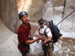
- Eric (left) and Mike stand safely above the carnage that is Lava Falls.
-

- Eric packrafts.
-

- David smiles during a calm section of the five mile packraft of the Colorado River.
-
- Mike rappels as Eric looks on in the Muav Limestone layer.
-

- Eric rappels and Mike hikes down through the narrows of the Muav Limestone layer.
-

- Eric rappels in the Redwall Limestone.
-
- Mike (left) and Eric struggle to pull the rope on a triple drop 180- foot rappel with a bend in the canyon. After changing angles, moving down canyon and using a jumar the rope came down.
-

- Eric rappels down through the Redwall Limestone.
-

- David rappels through the Supai Sandstone layer in the upper part of Cove Canyon.
Into new territory in Shinumo Wash

Shinumo Wash, 3BVR
approximately 11 miles
Navajo Nation/ Grand Canyon National Park, tributary Marble Canyon
09/18/10 – 09/19/10
.
The moon had yet to rise as we headed west on a dusty Navajo dirt road in a maze of roads, some nothing more than two tire tread marks through the desert scrub. Well over an hour after leaving pavement and only because we had a GPS, we arrived at our trail head right at the edge of Shinumo Wash, a deep and wide side canyon of the mighty Grand. As we laid down for the night the moon rose giving us a better sense of the vast country that surrounded us.
We woke with the sun, the heat following just behind. As we organized the last of our gear we knew it would not be long for the heat to completely catch up. We headed down the old Bureau of Reclamation Trail from the 1950s used to transport gear and personnel for a proposed dam site down at the Colorado River. For a side canyon, Shinumo was wide, vast and deep. The trail zig zagged down the steep canyon walls in the blazing sun to the sandy bottom strewn with boulders.
After hours of slogging down the not particularly pleasant canyon bottom surrounded by massive sandstone walls we approached a new layer of rock. As the drainage entered into this limestone layer the canyon narrowed into a beautiful slot and the real fun began. A pattern of either clean fluted rappels or slides of giddy excitement down polished limestone chutes into deep pothole pools of temperate water was the modus operandi of descent for the technical section. In these conditions the potholes were full and easily escapable and each one laid in the bottom of its own individual room before the next drop would take you into an entirely new chamber. Direct sun did not penetrate into the canyon bottom and despite the warm air and relatively warm water I was left with a slight chill through my body as we continuously submerged into and exited pools. Despite the slight shiver we took our time enjoying the rappels, the slides and the enormous insects who made this place home. The silver chambers of the slot had a campfire glow of light reflected from the sandstone walls towering over a thousand feet above us. Another rappel brought us to yet another room and we noticed dozens of footprints in the dried mud. This is the famous “Silver Grotto” a popular side hike from the Colorado River that rafters come up to from the river during their several week long trips through the Grand Canyon. Above this room where we came from, the rafters are stopped dead in their tracks from the drop we had just rappelled down. By now the roar of the river was easily heard and before not too long we reached the banks of the Colorado.
This part of the Grand Canyon like most of it, does not allow an exit up the fortress walls nor does it allow dry passage along its banks. The solution was to use small inflatable boats that we carried in our packs to float down to a section of the canyon where escape was possible. After inflating our pack rafts we launched into the swift current. Riffles splashed water over the boat that placed me only inches above the undulating surface of the river and entirely too soon we reached our camp for the night along a magnificent beach. The sounds of the river was the perfect background noise to a relaxing and enjoyable night of camping.
Despite several hours of unpleasant approach hiking, the previous day was full of beauty, fun, excitement, exploration and relaxation and we had barely paid much of a price for admission. What was the catch? On the exit hike back to our vehicle we found out. A real suffer fest; 5- hours, 2500 feet of elevation gain in complete exposure to the sun with temperatures hovering around 100- degrees. Truth be told I like to suffer a little. I find it cleansing. So for that ride I’ll pay the ticket price every time.
-David
-

- Floating down the Colorado River.
-

- The team gets their pack rafts ready to head down the Colorado River.
-

- The final slide into the final pothole before the river.
-

- The team works the canyon.
-

- Dylan negotiates.
-

- Refelections of the Grand Canyon in Shinumo Wash.
-

- Eric slides.
-

- Eric rescues a moth from being a victim of a keeper.
-

- Eric on rappel.
-

- Dylan sits in a beautiful room.
-

- Eric on rappel into the limestone slot of Shinumo Wash.
-

- Eric rests against canyon walls shielding himself from the angry sun.
-

- Eric on the hot approach.
-

- Dylan hikes down into Shinumo Wash.
-

- Dylan rises with the sun at our camp on the rim above Shinumo Wash.
Lower Waterholes Canyon, Part Deux

Lower Waterholes Canyon, (thru-trip to Colorado River) 4BIIIR
4.1 miles to river, 4 mile pack raft
Navajo Nation, tributary of Glen Canyon
04/25/10 – 04/26/10
.
This canyon was calling me to come back. On the previous descent, the route we took avoided the big drop by rappelling down a series of ledges along the side of the alcove. I feel this is an unsafe way to go. An abundance of loose rock near all of the anchors makes this route extremely dangerous. I was involved in the decision to go this way so the last thing I am doing is finger pointing, but since that descent over a year ago I felt a strong desire to return and do the descent the right way. Further, Laura, Eric and I had recently acquired pack rafts (small inflatable boats that weigh very little and when deflated can fit into a backpack) that we were anxious to put to use. The plan became to descend the canyon via the big drop and camp along the banks of the Colorado. The following day we would pack raft out to Lees Ferry and hitchhike the 35 plus miles back to our car. Okay, let’s go.
With just three people to divide the 700 feet of rope, pack rafts, paddles, personal flotation devices, wetsuits, sleeping bags, food, water, a water filter and a small cooking pot, our packs were bursting. Because of the weight and bulk of our packs it quickly became apparent that hanging our packs was mandatory to avoid flipping upside down while on rappel. A somewhat skinny section of canyon proved to be extremely difficult with all of our cargo. Never the less, we smoothly made our way through the rappels, down climbs, narrows and a Tyrolean Traverse to avoid getting wet in the pothole that had way less water than during the last descent. In fact we probably all could have skirted around the scum filled pool, but after Eric successfully maneuvered to the other side, Laura and I wanted the novelty of zip lining across.
As Eric lead the way on the final rappel before reaching the infamous Big Wall, I watched in horror as his 50- pound pack fell down the nearly 100- foot rappel, while he went to hang it off of his harness. Eric watched in even greater horror with the knowledge that his iPod Touch of 3 years was stored loosely in has pack. Once down at the bottom of the rappel Eric confirmed that his iPod was in fact a casualty, smashed to smithereens, along with a dented flask and cracked paddle.
After regrouping we started towards the beginning of the multi-pitch rappel down the Big Wall. We followed the drainage proper through down climbing a very narrow section of canyon towards a major drop ahead. Upon reaching the drop-off we could not find bolts anywhere. We did an about face and retraced our steps back up the down climbs which was torture with our huge packs through the narrow walls. At this point, Laura spotted the bolts of the start of the multi-pitch along a ledge canyon right above the drainage proper.

The first part of the multi-pitch is a 100- foot rappel down a very narrow crack. Leading the way I chose to hang my pack, which presented problems as it got stuck on the way down. At the bottom of the rappel where the crack was even narrower I spent several minutes getting my leg and pack untangled. Eric chose to keep his pack on for this rappel, which solved some of the problems I experienced, but he was troubled with not being able to turn around and see where he was going.
The second section of the multi-pitch is a short 15- foot rappel to the hanging station that provides the bolts for the 310- foot drop to solid ground. As I set up our rope for this monster, quadruple checking everything, Eric hammered sticks into the crack on the first part of the multi-pitch to help prevent the rope from getting stuck on the pull. Even after doing this, our rope still got stuck and Eric had to stem back up the crack 15 feet to dislodge the rope.
On the 310- foot rappel I chose to rap out of the bag hanging from my harness to avoid getting the rope stuck in the giant crack that goes down nearly the entire wall. This worked great but was a little scary when I would look down and see 300 feet of air below me with only four feet of rope hanging down during the descent. Once down on the ground I waited for Laura to follow with a fireman’s belay at the ready. Before I could make visual contact with her, my heart jumped out of my chest as I saw a dark object falling towards me. A paddle plummeted down and smashed into the rock next to me, cracking the shaft. Unlike her paddle, Laura safely reached the ground, followed by Eric. The multi-pitch took us two- hours, during which time all three of us were completely void of any thoughts except for the tasks at hand, a rarity in our lives today.
After packing up all of our rope I realized that my paddles were gone. I cannot say for sure what happened to them, but I suspect they fell out of my pack when we initially went the wrong way at the top of the multi-pitch. I was forced to drag my pack through the skinny section back up canyon and since I was in the back nobody would have noticed if they fell out. Though accidental, I feel terrible about leaving trash in the canyon. I always make a habit of picking up trash when possible during hiking or canyoneering and vow to increase this to make up for what I left behind. Further I would now have another challenge of getting the four miles down the river to Lees Ferry without paddles.

A few more rappels and mellow hiking brought us to the Colorado River. We enjoyed a magnificent night of stealth camping just off the banks of the river. The follow morning I woke up early and began devising a system of hand paddles that included small pieces of discarded metal I found and neoprene socks wrapped in the aluminum bags from the Mountain House meals that we ate for dinner the night before. After packing up and inflating our rafts we got on the water.
Pretty quickly it became apparent that my Mountain House hands were not going to work, but between the current, lack of wind and hand paddling with just the neoprene socks I was somewhat able to keep up with Laura and Eric. Keep in mind that they were both working with one broken paddle each. Despite our sorry paddle situation, we reached Lees Ferry much faster than expected.
We were able to get back to our vehicle at the top of Waterholes through a combination hitchhike. The first part was from a rafting outfit bus on its way back to Flagstaff after dropping off a group for their put in at Lees Ferry. He drove us to the Highway 89A and Highway 89 intersection. With our thumbs out for a half hour, a friendly and talkative Navajo man named Clifford came to our rescue and dropped us off at our car.
-David
-

- David rappels.
-

- Eric rappels.
-

- David zip lines across the pothole.
-

- Laura rappels down a crack 100 feet on the first part of the multi-pitch.
-

- Laura rappels the big drop.
-

- Eric shows his emotion immediately after reaching the ground following the 310- foot rappel.
-

- Laura rappels.
-

- Eric and Laura take in the Colorado River.
-

- Eric and Laura hang out by the river.
-

- David with his Mountain House hands for paddling and Eric with his paddles, one of them a casualty of a dropped pack, pose for a picture before heading down river in their pack rafts.
-

- David hand paddles with neoprene socks down the Colorado River in a pack raft.
R2R2R of the Grand Canyon

R2R2R of the Grand Canyon
47 miles, 11,000 feet elevation gain
Grand Canyon National Park
03/09/07
It is not the world’s deepest canyon, but there are no others on this planet that match it’s sheer enormity. 47 miles, 10,500 feet elevation gain. In one day crossing this grand chasm from rim to rim, turning around and retracing your steps to begin where you started. It is the rim to rim-to-rim challenge or R2R2R, as many know it.
With the moon hidden behind the horizon I began descending the Bright Angel Trail at 4 am with almost no natural light. The spotlight of my LED headlamp illuminated the trail as I weaved around iced over puddles and a few patches of snow. Finding my jogging pace I could see my breath in the 20-degree weather as I made my way down the switchbacks. Light began to fill the sky around the same time that I could begin to hear the roar of the Colorado River. As day began to take over night I realized my first blunder was forgetting to apply or pack any sun block. Such a minor mistake could be both detrimental to the success of the challenge and to my safety on such an extreme physical adventure. Fortunately just before I reached the bridge spanning the Colorado River I ran into a German backpacker who gave me a healthy portion of sun block.
9.6 miles and 2.5 hours into my journey I took a quick break near Phantom Ranch and continued jogging up the North Kaibab trail. As the trail began to climb out of the bottom of the canyon my mostly jogging some walking combination began to pendulum.
After reaching the Roaring Springs Trail junction I broke out my iPod; which supplied much needed mental energy for the tough switchback climbing ahead. To the sounds of the Red Hot Chili Peppers’ Stadium Arcadium I found a powerful walking stride. The jogging had ended long ago but I found my rhythm and was making good time. I spotted a group of backpackers 3 or 4 switchbacks above me and played a mind game to catch them as quickly as possible. Blowing past them, I continued power walking under the Supai Tunnel through patches of snow until I reached the North Rim at 7 hours elapsed time. I took a quick break on the rim that was covered in deep snow and then began heading back down the canyon.
My plan was find a slow and steady jog all the way to the Colorado, but after about a mile I realized that was not going to happen. My legs and feet just didn’t feel like they had it in them so I resorted to walking. The further down I got the more my feet and lower legs became a bother. I took about ten minutes soaking my lower extremities in the icy cold waters of Bright Angel Creek, which was a tremendous help. Reaching Phantom Ranch at 12 hours elapsed time I was exhausted. My feet though not blistered felt like hamburger. My legs were weak and my stomach was beginning to ache. I knew the climb up the south rim was going to be the hardest physical thing I had ever done.
I felt like I was crawling even though I was walking. With constipation cramps from too many energy bars my stomach got worse. Before I reached the Indian Gardens Camp it got dark. The final three miles were excruciating. With no moon I was unable to monitor my progress as the canyon walls, the rim and the dark sky blended into a plain of blackness. Dust mixed with tiny particles of dried mule manure filled the air and coated my nasal passages and the back of my throat. I just kept on taking another step.
After 17 hours I reached the South Rim and my car in the parking lot. A short drive took me to my hotel room in Tusayan. When I placed my key card in the door a red light blinked before me. I tried several times to no avail. My room could not have been any further from the lobby in this large hotel. I remember the slow excruciating hobble to the lobby and back to my room as the hardest part of the journey. It would be another four days till my walking completely returned to normal.
I am not sure that I would call this challenge fun and I probably would only do it again with a partner, but it was without question the most testing physical exercise I have ever performed. It took Mother Nature six millions years to create a feature who’s size and scope can not be appreciated through words or images; how could crossing it and back in one day not be worth it!
-David
NOTE: I did not bring a camera on this hike. The lead image of this post from a previous visit to the Grand Canyon.
Near epic in Waterholes Canyon
 Lower Waterholes Canyon, (thru-trip to Colorado River) 4BIIIR
4.1 miles
Navajo Nation, tributary of Glen Canyon
03/02/09

.
The number of phone calls, texts and emails in the planning for our full descent of Waterholes Canyon to the Colorado River, blew past a dozen on its way to losing count. A full descent of Waterholes Canyon is serious business and can be a logistical nightmare.
The reason for this is the canyon involves a 400- foot sheer vertical drop to the alcove below, known among some as the “Big Rap” and the fact that the canyon ends at the Colorado River miles upstream and on the opposite of Lees Ferry (the starting point for rafters of the Colorado River). Thus this canyon requires the use of some sort of boat to get from the bottom of Waterholes Canyon to Lees Ferry. Fortunately, Eric had a large inflatable river raft and a small kayak. Our solution was this: the day before we used the rafting company, Colorado River Discovery to shuttle Eric, his raft and kayak to the bottom of Waterholes Canyon. Eric then stowed his raft safely on shore and kayaked back to Lees Ferry. The following day the raft would be waiting for us at the end of the canyon. That is of course if we survived the “Big Rap”.
Waterholes is a beautiful Colorado Plateau slot canyon with sandstone fins creating a natural tunnel of art. While soaking in the beauty, negotiating tricky rappels, down climbs and squeezes, the thought of the Big Rap was always in the back of my mind. The first difficult technical challenge came when we tried to avoid getting wet in a pothole filled with cold green sludge. Mike took one for the team getting wet while crossing the pothole and then with my assistance set up a tension line over the pothole. With this line everyone else on our team crossed above the pothole and avoided the slime below.
Shortly after the pothole we hit the top of the alcove and the Big Rap. With a 325- foot rope and hundreds of feet of other rope we had options on how to make the descent of this sequence. During a survey we spotted bolts on a series of ledges on the side of the alcove. We had heard about this potential route. After exploring this area more closely a group decision was made to attempt this descent as opposed to the more traditional descent straight down the watercourse.
Five hours later we reached solid ground on the canyon floor. The route took us down three rappels off of ledges with exposed traverses and belayed down climbs through loose rock to bolts that were partially hidden in a buildup of sediment. We suspect this route had not been previously used in a decade or more. Later we talked about how we felt like we had gone back in time resurrecting the route. Everyone in our group got through the sequence without major incidents, but this was during five stressful hours. Fortunately the bolts appeared relatively solid and we had a bolt kit if necessary. I feel a responsibility to say that I DO NOT RECOMMEND THIS ROUTE.
Just before sunset we reached the Colorado and Eric rowed us to Lees Ferry below the massive cliffs and darkening sky. The mood was celebratory with an intense feeling of having just experienced a near epic adventure.
-David
**** To see a video produced by Mike Schennum of our descent down Waterholes, along with a hike to the Wave and a trip through the Egypt 2 and 3 slots from the same weekend go to the post “The Egypts – Not for those who weigh more than 200 pounds”.
-

- Eric hikes in the start of Lower Waterholes Canyon.
-

- A carcass of a coyote withers away in the bottom of the canyon.
-

- Chris on rappel.
-

- Krista climbs out of a pothole.
-

- Krista and Brandy wait on a ledge for their turns to go on rappel on the uncovered route down the alcove.
-

- Krista uses the tyrolean traverse to cross above the sludge filled pothole below.
-

- Krista and Brandy wait on a ledge for their turns to go on rappel on the uncovered route down the alcove.
-

- Brandy on rappel during the second of the three rappel sequence down the uncovered route in the alcove.
-

- Krista and Chris enjoy the ride down the Colorado to Lees Ferry and our car.


2 comments