The formation of a group in Upper Jump Canyon

North Fork of the Kings River, aka Upper Jump Canyon, 3CIII
Sierra National Forest
8/17/14
.
During the planning phase of the trip there had been discussion of trying to do Upper and Lower Jump Canyons in one day. For clarification it is just one canyon, the North Fork of the Kings River. The canyon is broken up into two sections: Upper Jump and Lower Jump. Upper Jump actually ends right where Lower Jump begins. Though it would most certainly be possible to complete both routes in one long and exhausting day with a small and speedy group it wasn’t for us on this trip. Logistics made sense to do things out of order and hit Upper Jump second.
Before feet touch rock, water, dust and mud, planning and scheming occurs. It is a necessity of canyoneering. Last minute additions join; injuries and exhaustion result in one less. It all creates different groups tackling different drainages. It is a beautiful part of the sport. This is the first time this exact semblance of people has ventured into narrow places.

Mike’s head pops up after jumping into water.
For me and a few others in the group this will be my last day of this California canyoneering holiday. As I romp through the somewhat unpleasant long start to this canyon I become reflective. Will this exact group ever form again? A snake stretched out on a tree branch hanging right over a pool of water we swim under jolts me out of my own head space. Shortly after this the canyon gets going. A few fun jumps, a gorgeous boulder cave, long hallway swims and some awkward rappels that could become extremely challenging if flows were considerably higher, highlight the technical section. Upper Jump falls flat compared to the down canyon route, but it is still a pleasant half day route.
The spot that began yesterday’s adventure presents itself and we are removing our harnesses and wetsuits. This group of six: Cody, Daisy, Mark, Chris, Mike and myself charge up the mountainside and back to our vehicle. We pose for a group picture, exchange hugs and handshakes and then splinter into sub-groups, heading our separate ways.
-David
-

- Cody having fun in Upper Jump Canyon.
-

- A snakes stretches out and sticks out its tongue on a tree branch hanging over a pool in Upper Jump.
-

- Mark moves through a gorgeous boulder cave in Upper Jump Canyon.
-

- Cody rappels through a three ribboned waterfall in Upper Jump Canyon.
-

- Mark treads water in front of the same spot.
-

- The crew entering a long hallway swim.
-

- Chris jumps.
-

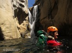
- Mike’s head pops up after jumping into water in Upper Jump.
The hype is real in Lower Jump Canyon

North Fork of the Kings River, aka Lower Jump Canyon, 3CIV
Sierra National Forest
8/16/14
.
This is the canyon. This is the one the whole trip is built around, Lower Jump Canyon. The Interweb loves it, drawing lots of attention as of late. Cali canyoneers keep raving about it. It was only a matter of time before their inland cousins in Utah, Arizona and Colorado started venturing west to check it out. A couple of our friends did just that last season and they fully concurred the hype. Schedules align and we make the 12- hour drive to check it out for ourselves.
Just as we pull out of our water parched campsite to set up the shuttle for Lower Jump so do another group of canyoneers from LA. They are also headed to Lower Jump. We follow just behind their vehicles along a paved road on the banks of the bony Kings River and into the Balch Camp, another town built for the workers running the dams to create hydroelectric power for Southern California. Mike comments how it reminds him of the movie “Chinatown” with Jack Nicholson. I add it to my to watch movie list.

After the shuttle is set and the short approach complete we suit up on the banks of the North Fork of the Kings as it is called on the maps. Just ahead of us are two separate groups of at least six people each, including our campsite neighbors. Just minutes separate each party creating the potential for a real cluster fuck. The wheels in my head are spinning to figure out a way to considerately pass these groups so we are not on top of each other during the 9- hour descent. Fortunately, the wider nature of the canyon allows us to begin sending part of our group down off of meat while sending the rest down on the natural anchor. At the next drop we all jump as the group just ahead of us are rappelling. One party is completely passed. At the following drop we again use the meat technique for everybody but myself. The other group kindly allow me to use their rope to rappel down. We are now entirely out in front. The canyon gets going and we are in it, really feeling this place. Jump after jump, true Class C rappels with the deafening sound of water colliding with plastic helmets and endless swimming ensue. Never have I swam so much in a canyon before. I would be curious as to the total distance we swim on this day, but I wouldn’t be surprised if it approaches a mile. The middle section of the canyon opens wide with a series of especially long pools. The banks of the river are chock full of thick vegetation so a slow mellow back swim under a blazing sun while taking in the granite canyon walls above is clearly the path of least resistance. Ripe blackberries hang over these pools allowing for mid-swim snacks along the way. Despite this tranquil description it is still exhausting.

A lower technical section develops giving us the opportunity and misfortune to core shot a rope between a 150 foot plus and 100 foot plus rappels with nothing but a pool and ledge separating them. We now do not have one piece of rope long enough to complete the rappel. We could tie two ropes together to reach the bottom but the knot would then not allow us to retrieve our rope. After spending ten minutes brainstorming as a group to figure out the best way to tackle the problem we come up with a solution. We tie two ropes together and then perform a rap and lower for all but the last person. Our last man at risk, Mike, then raps over the compromised section of rope which is about 30 feet above a deep pool of water. Mike reaches the bottom with the rope still intact.
More slogging, down climbs through boulder mazes in the gorgeous late afternoon light and a final jump bring us to just above a dam and powerhouse and the end of the canyon. As our top car is retrieved snacks and beers are brought out. We all have that glow and buzz from having just descended a really good canyon. Those two other groups emerge not long after us and they look the same way. No doubt Lower Jump is the real deal.
-David
-

- Cody on the first big jump of the canyon.
-

- Daisy comes down the best rappel of the canyon.
-

- Chris getting air Lower Jump Canyon in the Sierra Nevada Mountains.
-

- Daisy in the “Rainbow Room” in Lower Jump Canyon.
-

- Mark
-
- Chris
-

- Scott on a tough Class C nuisance rappel.
-
- Scott rappels.
-

- Chris and Scott in beautiful light in Lower Jump Canyon.
-

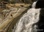
- Cody on the final jump of Lower Jump Canyon.
A long drive to massive hydroelectric energy in Canyon of the Dammed

Big Creek, aka Canyon of the Dammed, 3CIII
Sierra National Forest
8/15/14
.
According to google maps it is a 10.5 hour drive to Canyon of the Dammed, this first stop on our whirlwind Sierra-Nevada canyoneering tour. We actually picked this canyon because it has a shorter drive time than the pièce de résistance of the trip, Lower Jump Canyon. Leaving Phoenix after a full work day we know we have a nasty drive in store for us. With overheating issues those 10.5 hours become 12 and we pull off to the side of a dirt road to bed down for the night at 4:30 AM, just a few miles from Canyon of the Dammed. Three hours later we are getting our gear together. In an exhausted state I attempt to acclimate to my new surroundings. During those 679 miles we have left the desert and entered into a world of mountains, pine trees and massive granite features.
We set up our lower car shuttle in the town of Big Creek. The town has been built around Southern California Edison’s Big Creek Hydroelectric Project. We park a car not far from the powerhouse that creates hydroelectric power from the drainage that we will be descending. The structure is enormous and is one of 9 powerhouses generating a total capacity of 4 billion kilowatt hours a year, serving 4.3 millions customers in Southern California. It accounts for 12 percent of all hydroelectric power in California. It is fascinating to think we will be traveling through and be surrounded by the water and geography that makes all of that energy possible. We continue our drive through the town of Big Creek, not a person in sight at this early hour. The town appears to exist purely to serve the Big Creek Hydroelectric Project. We switchback on a paved road up over two thousand feet to Huntington Lake, a reservoir, also part of the Big Creek Hyrdroelectric Project. In California’s historic drought, the lake is frighteningly low. The lake is at a third of its normal level. Tree stumps from when the lake was created in 1912 are exposed and docks lay in dirt far from the shoreline. Check out this story from the Los Angeles Times with amazing photos showing the retreating Huntingon Lake. I begin to wonder for how much longer will the Big Creek Hydroelectric Project be able to provide electricity to charge all those smartphones and run all those air conditioners. In the more immediate future is there go to be all that much flow for our descent.

At the start of the approach, Cody walks by Huntington Lake. With the extreme drought in California you can notice how low the levels of the lake are.
We throw on our packs and walk alongside pipes, rails and other various infrastructure, of the hydroelectric project. Much of it appears to have been long decommissioned. As we work our way down a steep slope into the Big Creek drainage we are pleasantly surprised to see it is flowing considerably higher than from what we could see when we parked our bottom car. We now suspect that what we were seeing was after much of the water had been pulled out of the drainage for the powerhouse. Two thousand feet above there is enough water that I am second guessing my decision not to have brought my additional neoprene vest.
We get in it and begin to work the down climbs, rappels and slides. It is a place dominated by granite, way slicker than the sandstone we are more accustomed to. The canyon itself never really tightens but the adventure is exciting just the same and the scenery magnificent as we work our way towards and then past the massive granite feature known as Kerchoff Dome. One rappel is particularly exciting with the line right through the water course. As the descent nears its end we move past more pipes, wires, bridges and a small dam. A few more rappels past this and we can begin to hear the loud hum from the powerhouse. As I change out of my wetsuit studying the imposing quality of the powerhouse I am buzzing from an exciting Class C descent. I can’t help but wonder if the drought could put an end to what I just experienced and make the entire Big Creek Hydroelectric Project irrelevant.
-

- At the start of the approach, Cody walks by Huntington Lake. With the extreme drought in California you can notice how low the levels of the lake are.
-

- Daisy working an obstacle in Canyon of the Dammed.
-

- Scott in Canyon of the Dammed.
-

- Canyon of the Dammed in the Sierra Nevada Mountains.
-

- Mark control slides down a granite face into a large pool.
-

- Chris rappels.
-

- Mark rappels.
-

- Daisy rappels in front of a massive granite dome known as Kerchoff Dome.
-

- Daisy jumps.
Sin City weekend in Ice Cube Canyon

Ice Cube Canyon, (The Maze) 3BIV
Red Rock Canyon National Conservation Area
8/9/14
Vegas, it’s where two swinging bachelors run away to for the weekend. Well, we aren’t exactly swinging bachelors and this isn’t exactly your typical Vegas weekend. No Blackjack, strip clubs, Penn and Teller and all you can eat buffets on this 48- hour romp in Sin City. Well actually, there was not one, but two all you can buffets that were hit up, but the marquee event of the weekend was a descent of Ice Cube Canyon, also known as the Maze in the Red Rock Canyon National Conservation Area, just 20 miles from the Strip.
Its late on a Friday night and Eric and I roll into a second rate resort and casino, on the outskirts of Vegas, not far from the Red Rock Canyon National Conservation Area. Despite my online reservation we are given keys to a smoking room. I object, but am told it is all they have available. I try to guilt them in to giving us some sort of comps. I am told this isn’t the Strip and they don’t do comps. I walk away with keys in hand and tail between legs. I am a real high roller. We enter our room and it smells almost as bad as the casino floor where at midnight droves of senior citizens are smoking Pall Malls while playing the slots. I am annoyed but know in less than 8- hours I will be a world away.

No car shuttle for us, so we will have to make the 3500 ascent by foot. We hit the trail early to beat the worst of the heat. By the time the sun gets to us we are at elevation and the temperatures are quite manageable. The scenery is vast, really giving a sense to the size of wilderness in Nevada. We top out and cross the ridge, the entire Strip and its one of a kind skyline clearly visible. We drop into Ice Cube Canyon and immediately encounter an enormous group. I don’t recall their exact numbers, but it was approaching a baker’s dozen. Eric and I decide to delay putting on our wetsuits so we can get a jump and get in front of this group. When we wade into the first pool of water it is entirely comfortable. We reach a swimmer, submerge, exit and not a single chill in the body. We keep moving and soon realize the wetsuits we brought are unnecessary. We turn a few rappels into challenging down climbs and that group is long behind us.
It’s just us and the canyon now. Its spectacular and way skinnier than I was expecting. The down climbs keep coming and they are not easy. Normally water this clear and fresh is bone chilling. Recent monsoon rains and warm temps have created the perfect conditions for dark, slotty, Class B canyoneering. The canyon opens up for awhile affording outstanding views of the surrounding countryside. The canyon narrows again with more swims and rappels. We pass the keeper of Ice Cube Canyon, a massive skull and horns of a Big Horn sheep. It sits on a ledge and may weigh 40 pounds. Its size and weight keep it in place and deter it from becoming a Vegas souvenir, just the way it should be. A rappel, hallway, rappel sequence brings us to the desert floor. We boulder hop to pavement, stash our packs under a tree and jog the approximately two miles in the stifling triple digit temps. That is Eric’s idea, but I was all on board. It is an agonizing 20 minutes
Back at the resort, a shower, a few pre-game cocktails and these two bachelors are ready to hit the town. An all-you-can-eat buffet, some poker and a few laps around the casino floor and we are in bed by 11pm. Like I said not your typical Vegas weekend.
.
-

- Eric on the approach.
-

- Reaching the ridge above Ice Cube Canyon.
-

- Eric on a tough down climb early in the canyon.
-

- Eric exits a pothole.
-

- Plenty of beautiful scenery.
-

- Eric rappels….
-

- and pulls the rope.
-

- Not living.
-

- Also not living in Ice Cube Canyon.
-

- Eric in a beautiful hallway in Ice Cube Canyon in the Red Rock Canyon National Conservation Area.
-

- Eric moves through a gorgeous section of canyon. Looks like some good rock climbing potential here.
-

- Portrait in front of the cave section.
-

- On the final rappel.
-

- Superman.
-

- For some reason we decided to run the 2- miles to retrieve our car in triple digit temps. You can see Ice Cube Canyon (background left).
Bailey Canyon & Beach, in the same day

Bailey Canyon, 3AIII
3 miles
Angeles National Forest – San Gabriel Mountains
09/26/12
.
Like many Arizonians, every year Laura and I make an annual summer trip to San Diego. It is not only a chance to escape the heat and soak in the beautiful southern California coast, but an opportunity to spend quality time with one of my closest childhood friends, Tanner, who has made San Diego home. Tanner has made a number of trips to Arizona, during which time I have introduced him to canyoneering and we have shared in several descents. During this San Diego vacay I thought it would be fun to take a day off from the beach and drive up to the San Gabriel Mountains for some southern California canyoneering.
We leave early to beat the LA rush and arrive in the front rage of the San Gabriels entirely shrouded in fog. As we climb up into the mountains and the sun rises higher into the sky, the fog burns off making for some dramatic views. By the time we reach the start of the canyon, the fog is long gone, the sun is out in full force and we are excited to escape into the shadows of the canyon walls and begin the descent.
The canyon is bone dry and chock full of vegetation. Fortunately we are wearing long pants and these southern California plants are far more friendly than those in Arizona. Despite the canyon’s mellow attitude, it features a number of down climbs and up to a dozen rappels, including a long 110- foot drop, giving Tanner lots of opportunity to practice his canyoneering skills.
The day is light and fun with lots of humor, the kind of laughter you can only share with someone that you grew up with. The only tense moments come from a swarm of bees hanging out at the bottom of a drop searching for water and a rattlesnake soaking in the sun on a ledge part way down a rappel. Fortunately for us, the bees and the rattlesnake mean us no harm and allow us safe passage. We finish the adventure and return to our car early in the day allowing us to once again avoid rush hour. Arriving back in San Diego I Immediately walk out to the beach to join Laura and Wyatt already playing in the sand and ocean. You can’t do that after a day of canyoneering in Arizona.
– David
-

- Tanner hikes through the fog on the Bailey Canyon Trail during the ascent.
-

- The fog begins to clear.
-

- Tanner on the 110 – foot rappel.
-

- Tanner about to rappel.
-

- Tanner down climbs in a nice section of narrows.
-

- Tanner rappels.
-

- Tanner rappels.
-

- Later that day David and Wyatt have fun in the ocean at Solano Beach.
Cali Canyoneering – Lower Eaton Canyon

Lower Eaton Canyon, 3BIV
8 miles
Angeles National Forest – San Gabriel Mountains
05/30/10
.
The hike up the popular Mount Wilson Toll Road trail to get to Eaton Canyon was sizzling in the mid-morning southern California sun. With frequent breaks in scarce shade we were treated to a panoramic view of Los Angeles and if it weren’t for the typical heavy haze of smog we could have seen the ocean from the foothills of the San Gabriel Mountains.
Eaton canyon is a natural wonderland on the outskirts of Los Angeles with warm water flowing down a steep canyon filled with trees and other beautiful vegetation. The canyon also features many natural water slides (although after the devastating Station Fire of last year, many of the drops that were once water slides into deep pools are now rappels because the canyon has been filled with much sand and debris).
I was still rappelling lefty after injuring my hand in Sunburst the week before but that was not going to keep me from going down Eaton. It was great to get out in a canyon with Chris who I had not descended a canyon with in nearly a year. After numerous rappels and down climbs through the considerable flow we began noticing graffiti on the canyon walls. The spray paint on the walls definitely took away from the gorgeous natural setting.
The final two rappels in Eaton are through slippery waterfalls directly down the watercourse. If rappelling while being pummeled by water is not enough you are greeted with the added pressure of a considerable audience from below, as the final two waterfalls are popular hiking spots reached from walking up the canyon. I have never seen such a crowd at the bottom of a rappel! Both Mystery and Imlay canyons in Zion National Park have final rappels into the Narrows, which can give you an audience of a few hikers but they don’t hold a candle to an Eaton rappel on a Sunday afternoon. Chris was the first to go down and he got cheers from over 50 people hanging out at the base of the waterfall. After our group of six made it safely through the final rap without embarrassing ourselves we hiked out of the canyon passing quite literally a hundred people.
-Laura
-

- Rapping in Lower Eaton
-

- Getting pounded on rap.
-

- Beauty of a rappel.
-

- With an audience below.
-

- Don’t mess up here.
-

- Bagging the rope.
Cali canyoneering – Rubio & LSA Canyons

For Memorial Day weekend, Laura and I drove across the desert to Los Angeles to see our good buddy Chris, get a little beach in and get a taste for some Cali canyoneering in the San Gabriel Mountains. The plan for the first day was to do the East Fork of Rubio into Rubio Canyon, a long and challenging day. After dropping off one of our shuttle vehicles at the bottom of Rubio in a residential neighborhood, which was in stark contrast to the canyoneering I am used to in wilderness far removed from civilization, we attempted to drive up into the Front Range via the Angeles Crest Highway to the upper trailhead for the East Fork of Rubio. A road closure on the Angeles Crest Highway from last year’s Station Fire and the heavy rains over the winter turned us around and we were forced to change our plans.

Rubio Canyon, 3BII
5.5 miles
Angeles National Forest – San Gabriel Mountains
05/29/10
Still nursing her bruised hand from Sunburst, Laura dropped us off at the trailhead for Rubio and wasted no time heading directly to the beach. For Chris and I, the hike up into the Front Range was a on a popular trail to say the least. We passed dozens of hikers as we switched back and forth up into the hills with views of the entire metropolitan area below us. Even through the smog, downtown Los Angeles did not look too far away.
Breaking off the trail we made our way into the canyon, which had a slight flow down the drainage. As we followed rusted pipes down the canyon, we made our way to the first rappel, an 80- drop down Thalehaha Falls. The descent was followed by several more rappels none of which were as interesting as the first. One of the rappels was down the remnants of an old dam. At the start of another rappel, the skyline of downtown LA was clearly visible. We quickly reached the end of the canyon and walked passed homes with manicured lawns back to our car.

Little Santa Anita Canyon, 3CII
4 miles
Angeles National Forest – San Gabriel Mountains
05/29/10
With still a lot of light left in the day, Chris and I hopped on the freeway, sat in a little bit of traffic and drove to the trailhead of Little Santa Anita Canyon (LSA). Another switchback hike under a blazing mid-afternoon sun brought us to the canyon that had a lot more flow than Rubio. LSA was a blast with close to ten continuous waterfall rappels through delightfully warm water or at least warm compared to what we are used to. Like Rubio, the canyon is way over bolted. With the abundance of natural anchors the bolts are unnecessary but makes descent of the canyon quick and easy despite the concentration of rappels. At the end of the canyon, another hike through a residential neighborhood brought us back to out car.
-David
-

- The metropolitan Los Angeles Area including the downtown skyline is seen beyond Echo Mountain on the approach hike to Rubio.
-

- Chris rappels down Thalehaha Falls in Rubio Canyon.
-

- Chris hikes along the creek at the start of LSA.
-

- Chris rappels in LSA.
-

- Chris pulls the rope in LSA.
-

- Chris in LSA.
-

- Chris rappels in LSA.
-

- Chris hikes in a narrower section of LSA.
-

- Chris walks through a residential neighborhood on the exit hike from LSA.


leave a comment