The Year, Part III – The lightest of days in Diana’s Throne Canyon

Diana’s Throne Canyon, 3AI
BLM land east of Zion National Park
3/26/17
.
To keep this train moving before the engine locks up and it never starts again, here is a quick report, of a quick descent from over a year ago. It was however part of the narrative of The Year, that year being 2017, for those keeping track.
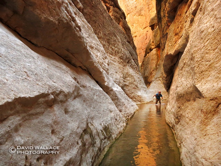
After the terrifying descent down Behunin Canyon, the day before the group was looking for something light before heading home. Diana’s Throne Canyon, aka Huntress Slot, aka Elkhart Cliffs Canyon, aka Diana’s Canyon, seemed to fit the bill. It did and with the weather a complete 180 from the day before we got our muscles moving in the canyon lands for a few hours of fun in a charming and novice slot before the long drive home.
Next up a return to Climax (for whenever that may be).
-David
-

- Eric and Mark in a charming section of the slot.
-

- Brian handlines down a short drop.
-

- Eric
-

- Pat looking up and what I believe was an owl’s nest.
-

- The short and simple exit hike.
Odds and ends in Blue Pools and Boulderfest Canyons

Canyoneering can be intense, multi-day and on occasion can quickly become epic. Other times it just is a way to relax and spend a portion of the day with a litter of water and some rope and relaxing in some narrow places. These types of adventures don’t leave behind much to say about them but they still enrich your soul. With 2016 faded into history and the arrival of 2017 I thought it would be a good time to dust off some odds and ends of two half day adventures of the past year, where not much happened. That was what was so nice about them.

Blue Pool Canyon 3AI
Lake Powell area
June 2016
.
After an intense all day adventure descending Checkerboard Canyon in Zion National Park the day before all I had in store for this day was the seven hour drive back to Phoenix. To break up the drive I decided for a quick solo descent down Blue Pool Canyon. I had spotted this slot while driving over it on U.S. Route 89 en route to other canyoneering adventures in southern Utah. It had always looked enticing at 60mph so for the first time instead of driving over it I pull off into a sandy parking area, gear up and head under the bridge. A few easy drops, a few photos and a little bit of walking and the slot opens up. I navigate my way out of the canyon into the sandstone world above and back to the highway, enjoying the quiet, solitude and exercise before the remainder of my drive home.

Boulderfest Canyon 3AII
Superstition Wilderness Area
10/25/16
.
When one of my closest childhood friends was in town visiting, as the host I was charged with the task of filling our days with activities; being the camp director so to speak. Like Blue Pool Canyon, Boulderfest Canyon, had always been on my mind from the dozens of times I would look at it while driving past Canyon Lake en route to other adventures. I knew a descent would take no more than 2/3 of a day with driving, the weather was agreeable and I thought Seth would get a kick out of the packraft across the lake, assuming we did get killed by a powerboat driving over us. The packraft was unremarkable under a hot Autumn Arizona sun. It did requires some muscle to make it across but we got there. Even more challenging was deflating out boats with no flat shoreline. Up and over a saddle and down the other side and we were in Boulderfest. You could see the lake for the entire descent. Seth faced his fear, managed the rappels and down climbs and rather quickly we were re-inflating our boats for the float home, or at least back to our vehicles. Seth and I were back home, showered and in time for a 7pm dinner reservation.
CLICK ON IMAGE BELOW TO BEGIN GALLERY.


Virtual Reality in Punchbowl Canyon

David holds the two GoPro Virtual Reality rig while planning out a shot in Punchbowl Canyon.
LOOK BELOW TO WATH THE CANYONEERING 360 DEGREE VIRTUAL REALITY PIECE.
.
Punchbowl Canyon, 3BIV
Tonto National Forest – Superstition Wilderness Area
12/4/16
.
“This fuc*ing camera!,” I mutter to myself as I’m fumbling with two modified GoPro cameras on a rig so their backs are butted against each other and the lenses face 180 degrees apart. Once I get the shot I want laid out and get both cameras recording, I begin floundering with my two sets of lavalier microphones connected to an audio recorder via a wireless receiver. I am deep in a cold, wet slot canyon in the Superstition Mountains of central Arizona. I clap my hands several times loudly to sync the two GoPro cameras and audio recordings. I then yell “Action!” at the top of my lungs. Moments later Eric comes down a 120- foot rappel into a narrow hallway above me, as down canyon, Mike, Laura and Susan make their way across a frigid slimy pool of water. I stand somewhere in the middle watching all the action. The cameras record it all between narrow walls. This my first foray into 360 degree Virtual Reality video. A few months earlier several USA Today video producers asked if I could shoot a Virtual Reality video for them on canyoneering. Always eager to play and learn new technology and even more so, to get paid to go canyoneering, I jumped on the opportunity. After assembling a crew and picking a date we are out on the trailhead on a cold December morning. It was a canyon that our group of six had all done and were familiar with. In the past a descent of this canyon had taken as little as six hours. I knew today would take much longer.

A frame grab from the 360 degree Virtual Reality video in Punchbowl Canyon.
As the day progresses and shots are produced it becomes clear that battery life becomes my most precious commodity. As I push blinking battery bar indicators to their fullest I do my best to dot every “i” and cross every “t” while trying to record compelling 360 degree footage of this stunning, rugged and challenging desert slot. The hardest part of shooting VR is 360 degrees means everything around, above and below you is part of the footage. Making choices of what to include and what not to include becomes much more challenging than with traditional videography and photography. Combine this with the aforementioned clunky operation of the equipment in this hostile environment and let’s just say it wasn’t that typical day of canyoneering. Four hours past when we would have been to our vehicles on a normal descent and night is not far around the corner, but the last rappel is still at least an hour away. In the end we make that final rappel and much needed closing shot just before dusk. My crew was extremely patient despite the seemingly excessive production and time in these raw conditions. Kudos and much thanks to them. So without further chronicling let me present to you the finished video piece below. Since virtual reality video is a relatively new medium I have included a list of tips to help you better enjoy the experience.
-David
- The canyoneering segment starts at the 1 minute 38 second mark.
- It doesn’t work on the Safari web browser on either desktop or mobile. I suggest Chrome on desktop or the YouTube app on your phone.
- You need good bandwidth or the resolution will not be good and will make for a nauseating viewing experience.
- The best way to view is with your phone and a Virtual Reality headset but since most people don’t have headsets I still think with your phone is better than desktop so you can move the phone around and see full 360 degrees. On desktop use your mouse to navigate around 360 degrees.
- You really have to navigate around to see everything that is going on. You may have to watch the video more than once to do that. Try using a swivel office chair.
- I didn’t have anything to do with the title which I think is a little misleading and happens to be the same as Todd Martin’s book on canyoneering in the Grand Canyon.
Check out USA Today’s VR Youtube channel VRtually There.
Into the vastness: Kanab Creek

It’s been two months since I finally sit down to chronicle this trip. Much has happened since then. A presidential election shocked almost everybody, leaving those both in support and opposed to the President elect, unsure of what to expect. Through the uncertainty, the holiday front moved in, along with cooler weather. Throw on top of that relentless work and the obligations and joys of parenthood and those brisk details of this most recent adventure have fogged. One experience from this trip, however, stays well solidified in my consciousness and that is the notion of vastness. Though far from the first time participating in a multi-day adventure exploring the enormity that is the Grand Canyon, this trip really seemed to showcase that epic and stretched out land at an unparalleled level. Even before our soles touched this Earth it was big. On the drive to the rim, pavement over 30 miles back, we could sense the expanse in the darkness. The road ends on the edge of the rim, nothing but air in front of us. As we roll out our sleeping bags we wonder where the New Mexico and Colorado contingent of our crew are. We were supposed to rendezvous nearly 20 miles ago. They were not at the designated spot. Too much space and darkness to find them so we drove till we could drive no further, hoping they would do the same. I close my eyes looking forward to seeing what I already feel about this space and hoping the rest of the crew shows.

First light and a fresh pair of daily use contacts do indeed illuminate the hugeness of this place. Just 30 feet away the world drops into a sprawling complex; a massive multi-tiered canyon stretching for many miles in multiple directions. It is a canyon of epic scale, but it is also nothing more than a single side canyon; one of hundreds of adjoining drainages of the main corridor of the Colorado River’s Grand Canyon. It may be only a side canyon, but it is one of the Grand’s biggest. It is Kanab Creek. A side canyon so big that it has several dozen of it’s own side drainages. Kanab Creek is so extensive in its own right that we can not even see the inner corridor of the Grand Canyon from our current perch. All we see is the Kanab Creek system. Before I have time to really take in the view I can hear a vehicle approaching and within minutes our Colorado and New Mexico contingent arrive. Final packing is completed and we hit the trail to see what is lurking down below in this massive place.

Kanab Zero, 3BVI
Grand Canyon National Park
10/28/16
.
A game of chutes and ladders begins and we try to find a way past several cliff bands to get to the layer that will grant us passage to our side canyon du jour, Kanab Zero. Undulating up and down we slowly traverse further and further away from Kanab Zero. We eventually give up on a walk down past the Coconino cliff band and break out the rope to set up a rappel. Once down to the Esplanade we work our way back to “Zero” and finally into it’s clutches. We approach the edge of the Supai, a last dance with vastness before dropping into the labyrinth of the Kanab Creek system. What ensues is a sphincter puckering 400- foot, two stage rappel. Shortly after hitting terra firma the Redwall closes in and the real fun begins.

Rope and rappels, pools and swims, rain and sun, all within a world of polished white rock intermittently stained iron red. The scale of the place that we are deep within is becoming a distant memory as these walls are narrow and the views reveal only the beauty right before us. Eventually everything before the here and now fades away as the canyon’s aggressive technical characteristics keep us locked into the current moment and space. “Zero” is rather insignificant on the map; a short stretch before hitting Kanab Creek proper, but in this place distance and time don’t correlate. It’s consecutive rappels, almost all of which are of considerable height are eating up much of the day. Eventually we hear the sounds of Kanab Creek in the distance. A final drop brings our soles into the flowing water as dusk approaches. A short jaunt downstream and we set up camp on a creekside limestone bench.

Whispering Falls Canyon, (sneak route) 3BVI
Grand Canyon National Park
10/29/16
Another side canyon of Kanab Creek lurks just around a bend. To descend it we must first gain a level and traverse around to where we can drop in above these technical highlights. This route requires ascending a gully of rotten rock before traversing a narrow and exposed bench 500 feet off the desk. It is sketchy and exciting and then once in Whispering Falls canyon, the kosher fun can begin. Several obstacles present themselves but this half day adventure is all about the final crux rappel, a beauty of a drop down a spring fed chute which whispers “you are here,” over and over again in hushed tones. The whispering waterfall transitions into an exquisite hallway followed by a pool of turquoise water. Not long after and we are back to Kanab Creek and the long haul upstream through massive boulders, a prickly pear forest and numerous pools; a true slogfest through Water and Earth. The soles of Eric’s shoes become a casualty of the conditions and we are many steps into this place. By the time we hit the confluence with Scotty’s Hollow Eric has figured out to work his disabled shoes.

Scotty’s Hollow, (ascent) 3BVI
Grand Canyon National Park
10/29/16
.
In just over 30 hours we have seen and experienced a tremendous landscape both from above and within. We have worked our bodies hard to do so. Now to get out of this place we must push them harder. We quickly realize our ticket out of here will reveal a space of unique and unparalleled beauty, but the up-climb obstacles will require skin, athleticism and teamwork. They are numerous and they seem to get ever more challenging the further up we climb. The walls close in as the water flows down, the combination making the obstacles ever more challenging. I monitor the rim of the Redwall to watch it get lower the higher we climb, 300 feet, 200 feet, actually it might only be 150 feet and so on. Just when I think we are out another obstacle presents itself, until we are out for real. We find a sandstone bench for camp. We are out of the subterranean world and back into the vastness. Our day once again pushed nearly to dusk. We are exhausted and very content. We are treated to a magnificent sunset as the JetBoil is passed around.

.
From camp we can see our exit out of the Kanab Creek system to the rim above. It is big and imposing, three thousand feet of vertical through multiple sections that seem impassable. We are hoping proximity will reveal the path. First we must escape the Supai, a task in itself. We use a side drainage of Scotty’s. Perhaps a mistake but it does go after several exposed and technical moves. We then must circumvent the system to the route that will take us through the upper layers of the canyon. Once this is accomplished the real vertical attack begins. We find a good use trail that makes progress as efficient as possible. Teamwork is no longer required. It’s just put one foot in front of the other and breath. We find our rhythms and organically break into sub groups or go solo. As the path disintegrates more chutes and ladders are required through those sections that appeared impassable from below. It is challenging and sketchy but we find our way. Eventually Pat and I top out on the rim. We wait for the others. We say little and I don’t think about much. I am just here sitting on dirt, next to my backpack, right on the edge of the immensity. It feels good.
-David
CLICK ON IMAGE BELOW TO BEGIN GALLERY.


Too long since canyoneering on the Mogollon Rim – Immaculate Canyon

Immaculate Canyon, 3BIII
Coconino National Forest, tributary of West Fork of Oak Creek
08/14/16
.
It has been too long since experiencing this place between narrow walls. It was October 22, 2012, in fact, when Eric and I made a beautiful autumn descent of Barney Spring Canyon. This was the last time I descended a technical canyon on the Mogollon Rim. Over 8- years ago, in these sandstone slots hidden in this 200- mile long escarpment I fell in love with canyoneering. In 2012, around the same time that I last got on rope on the Mogollon Rim, Mark and Brian made a first descent of a canyon just next door to Barney Spring Canyon. They were in fact searching for a canyon posted by canyon guru Tom Jones called “Obfuscation Canyon”. It was posted with not much more than a few dramatic photos and a “Flagstaff, Arizona” location tag. Brian should have looked up the definition of obfuscation first, but he was on the hunt for canyons in the Flagstaff area. Instead of finding what he was looking for, he found and pioneered a first descent of a canyon that might just be better. Four years later Mark was back for the first time since that first descent, and I was back for my first time in too long in this magical place.

We begin the descent on a muggy, bug infested, Sunday morning. I am not feeling my best after a late night of too many Red Bull and vodkas while making an extended appearance at friend and fellow canyoneers, Chris Ngo’s party to christen his magnificent new pool. The party adding an hour’s drive was well worth it, but got us in late and starting the canyon a little off kilter as we negotiate thick vegetation making our way into the canyon. The dirty approach is short and the first drop comes in quick. As rope slides through my hands and device, my feet gingerly scamper down the vertical electric green moss covered walls. The magic of this place washes over me and the bugs, humidity and hangover disappear. Challenging rappel situations ensue requiring good technique to avoid sticking ropes and managing multi-pitch. “What a find!” I comment to Mark.

The canyon relents and we make use of a recently publicized sneak exit that allows us to escape from the West Fork of Oak Creek Canyon complex just minutes from the last rappel. It will save us hours and miles not having to circumvent around the entire system. The sneak is dirty and steep. Signs of the 2014 Slide Fire are everywhere with charred trees lined like burnt matchsticks overlooking the rim in all directions. It is slow going but direct and in under an hour we top out on the rim. We move through the remains of trees that stand over a carpet of green growing out of the scorched earth. The burned over area ends and we are back into the shade of the untouched Ponderosa Pines. Hello my old friends. Good to see you again. It is not that I haven’t spent time in the last four years on the Mogollon Rim or in Arizona’s massive Ponderosa Pine forest. To the contrary I have done numerous hikes and camping trips in this magical place in the last four years. For some reason it feels a little different walking under these trees after completing a canyon descent in the hidden slots below these majestic sentinels. Like I said before, it has been too long.
– David
CLICK ON IMAGE BELOW TO BEGIN GALLERY.


Checkerboard Canyon, a wild gem in an ever busier place

Checkerboard Canyon, 3BIV
Zion National Park
June 2016
.
First a warning. I let too much time get in the way before sitting down and writing about our late Spring descent of Checkerboard Canyon in Zion National Park, so a detailed cohesive report might be a bit lacking. Though easier than Heaps or Imlay, Checkerboard Canyon has the feel of a rugged, remote and wild canyon far removed from the hordes that descend the jeweled trade routes glimmering on the canyoneering crown of Zion National Park. If you want a detailed report you can easily find one out there but this won’t be it. Included are a few gems that cut through my memory fogged from rearing 3 children, too many hours working outdoors in the hot Arizona sun and too many after work cocktails.
Checkerboard eluded us last Fall when weather made a descent out of the question. I wasn’t going to miss it this time around, but 48 hours away from home was about all the time I had. This includes 14 hours of driving and around 12 hours for the descent itself. Driving solo and trying to make time I let my speed get the better of me and I’m pulled over east of Kanab by the Utah Highway Patrol. The trooper can not be nicer and lets me off with a warning, but not before he asks me about what are my canyoneering plans for the weekend. He tells me he has never descended Checkerboard. Needless to say my weekend could have easily gotten off on a worse foot had it been for a different cop.

Upon arriving the rest of the crew is already established at Zion Ponderosa Ranch Resort. It is more crowded than I’ve ever seen it. We awake before sunrise in preparation for the long day. The dozens of other campers still sleeping. The journey begins on the long approach along Dakota Ridge. As expected we have this part of the park all to ourselves. Though only a few miles as the crow flies away from Zion Ponderosa Ranch it feels a world away from the zip-line, swimming pool, ATVs and drunk campers. Ironically, we may have been some of those drunken campers last night but on this morning we are all business as we march efficiently across Dakota Ridge.
After a several hour approach the canyon begins in dramatic fashion and never really lets up. Some rather tough down climbs, tight squeezes, diagonal walls and awkward start rappels which are far more characteristic of points Utah east than normally found in Zion, are rather common in this canyon. Cold water comes in and so do humping frogs. Narrows are sustained and the canyon ends with a unique rappel dumping us just above the confluence with the North Fork of the Virgin River.

Spring run-off is still a factor and we are able to body kayak down some of the deeper sections of water. The higher flows and the fact that it is late in the day are keeping the crowds out of this normally busy place. We not only have Big Spring to ourselves but don’t see a single other person until we are just upstream of Imlay Rock. Soon as we get downstream of Orderville Junction the crowds explode. It is an international sea of humanity. I have never seen this many people in the Narrows in over half a dozen visits. Though it is wonderful to see so many people from all across the world connecting with this magnificent place it also brings up notions of ‘loving your park to death’. We reach the shuttle stop to find a line of people backed up well over a 100 -yards. The word comes down the line that it will be a 45- minute wait. As we wait I think back on the contrasts of the day. It’s good to know that wild and isolated places still exist in our smaller and more popular national parks. At least for now. It’s been a 100 years. I worry what it will be in another 100. We are on the shuttle in 30- minutes.
– David
-

- The sun comes up during the approach along Dakota Ridge.
-

- Brian fights his way through thick vegetation as we make our way into the Checkerboard drainage.
-

- Mark on the approach.
-

- Cody silhouetted on the first rappel of Checkerboard Canyon.
-

- Cody on the same rappel in the light.
-

- Mike rappels with a fireman’s belay from Eric.
-

- Mike takes in the canyon.
-

- Eric down climbs with a partner assist from David.
-

- Cody and Mark make their way through diagonal walls.
-

- Mark in more diagonal walls.
-

- Cody on one of the many awkward start rappels with the anchor backed up by Eric.
-

- Cody in a nice section of narrows.
-

- David working through the canyon.
-

- Mike gets on rappel as Brian throws the rope down to keep it moving forward.
-

- Mark wading through water.
-

- Eric on a tricky down climb.
-

- Mark makes his way through an open section of canyon where it looks like there was a somewhat recent rockfall.
-

- Mark bridging a section.
-

- Back in the dark narrows Mike wades through water.
-

- Mike clearly enjoying the show of canyon frogs fornicating.
-

- Mark rappels.
-

- Cody neck deep in cold water.
-

- Mike works the canyon.
-

- Cody reaches to exit a pothole.
-

- Eric on the final rappel of the canyon.
-

- Cody makes his way through the crack of the final rappel.
-

- David negotiating white water with nothing more than his body in the Narrows.
-

- The crew at Big Spring on the hike out in the Narrows.
The distant memory of winter in the desert – Upper Romero Canyon

Palisades Canyon, 3CIII
Coronado National Forest – Santa Catalina Mountains
1/17/16
.
SUMMER IS COMING.
Dreaded words here in the Valley of the Sun. It has hit triple digits, fire season has begun and winter in the desert is beginning to feel like a distant memory.
The National Oceanic and Atmospheric Administration was predicting the winter of 2016 to be the strongest El Nino in 18 years dumping abundant and much needed rain in drought stricken California and the southwestern United States. Abundant water in the desert is something special when it happens. Unfortunately, the El Nino never delivered as only a few winter storms materialized leaving far less snow in Arizona’s mountains and canyon country than what many were hoping for. No doubt water managers are looking back on the last six months with disappointment. And they aren’t the only ones. Canyoneers were hoping for a robust winter and spring season of Class C descents. It never really happened. But for me and my partners timing did strike as within a week of the most productive and wide spread storm of the season we descended Upper Romero Canyon in the Santa Catalina Mountains outside of Tucson.

The hike begins from Catalina State Park in that juxtaposed combination of brisk air and intense sun that helps define winter in the desert. We climb higher into the Santa Catalina Mountains. The roar of fast moving water can be heard distantly below in multiple places. The desert is alive and we are venturing to a place where we will become surrounded by that intense and fleeting energy. The nearly five mile hike and two thousand feet of elevation gain not only gets my heart moving but gives my mind time and space to absorb what I know will be a special opportunity.

Into that energy we go and for the others who have been here before they quickly note the way higher flows. Negotiating down climbs, rope and rappels while being pounded by all that water requires focus. The swims feature hydraulics which also require attention to detail. It’s a wild and exciting ride that is experienced by all five senses encapsulated in a bubble of adrenaline: the deafening thunder of water pounding helmets, the taste and smell of agitated water in the desert, the glow of sunlight bouncing off the not so blank canvas of polished white granite and cold water surrounding every square inch of my flesh. I am alive and taking advantage of this time, place and all of this water; in just the same way the desert is. Fast forward four months and it’s all just a distant memory. Again, for both me and the desert.
-David
-

- Eric makes his way into Upper Romero Canyon.
-

- Mark rappels.
-

- Mark swims a pool after getting off rappel.
-

- Mark hands a bag down to Cody to negotiate an obstacle.
-

- Light and shadows in Upper Romero.
-

- Mark makes his way through a hallway of white polished granite.
-

- Eric works his way underneath a waterfall.
-

- Pat rappels.
-

- Eric rappels.
-

- Eric getting off rope past a hydraulic.
-

- Pat rappels.
-

- Pat wades through water.
-

- Mark works his way down an obstacle.
-

- Mark and Pat make their way through a grass field on the short hike from the canyon bottom back to the trail.
A weekend away in the Jug and Campaign Creek

Campaign Creek, 2CI
Tonto National Forest – Superstition Wilderness Area
04/03/16
.
You have read stories of adventure and physical endurance, precarious wilderness situations and hairy navigational predicaments on this blog. Just scroll down and read about David’s epic 4 day, 40 mile, backpack, canyoneering and packrafting journey in the Grand Canyon for one of those heroic tales. This blog post is not that. This blog post is about getting away from home for a couple of nights, eating pizza cooked on a grate under the stars and rolling out of camp at the crack of 11am to hit up one of the most accessible and quite possibly the most wildly popular canyoneering route in Arizona, The Jug. I had not been in a canyon since Hawaii (while pregnant with the twins) about a year earlier so when I got wind of car camping + Jug decent I was in.

The Jug of Salome Creek, 3CII
Tonto National Forest – Salome Wilderness Area
04/02/16
.
The Jug was in perfect conditions for a leisurely afternoon in the natural waterpark. It was a crystal clear day and our rowdy group had the whole place to ourselves. A late night at camp with friends and a quite night’s sleep (read “no babies”) was just the little escape I was craving. Sunday morning Mark, Eric, Susan, Brian and I hiked a pretty little canyon through Campaign Creek before heading home again.
–Laura
-

- Susan and Eric wade through the cattails in the beginning of Salome Jug.
-

- Cattails snowing down on Chris in Salome Jug.
-

- Susan having fun.
-

- Lili enjoying a natural waterside.
-

- Making our way through the canyon.
-

- Laura loving the canyon.
-

- Susan in the Jug.
-

- Eric headfirst.
-

- Sang on rappel.
-

- Chris exits the canyon.
-

- Brian in the Jug.
-

- The view from camp.
-

- Campaign Creek
-

- The final pretty little section of Campaign Creek.
-

- Campaign Creek
-

- Campaign Creek
-

- Campaign Creek
-

- Eric emerging from a boulder cave.
-

- Mark showing off some skills in Campaign Creek.
-

- A little waterfall in Campaign Creek.
-

- Campaign Creek
-

- Susan and Eric in Campaign Creek.
-

- Brian (from left), me, Eric, Susan and Mark in Campaign Creek
A test in the grandest of places – Tuckup, National, Plan B & Pocket Point Canyons

An opportunity….
A chance to test myself physically. Four days, over 40 miles of canyoneering, off trail backpacking and packrafting, in a remote and rugged part of the Grand Canyon. Committing to the adventure somewhat late in the game I realize a little over a month out that I need to get myself in shape. A strict regimen of trail running and climbing to the top of Camelback Mountain with a 50 pound pack follows and rather quickly I’m feeling ready. Perhaps, this is the best shape I’ve been in a long time. I know my three partners will be prepared and planning on hitting the route fast and aggressively. I don’t want them thinking that the Dad of three has gone soft and can no longer keep up. I couldn’t be more excited to put my body and mind in this massive place and see how they hold up.

Tuckup Canyon descent, 2BV and Rocky Point Canyon, 3BIV
Grand Canyon National Park
4/15/16
.
On the rim final preparations are made to our packs and feet hit Earth. It won’t get any easier than this as the first few miles are on a moderate downhill grade on the Tuckup Trail, the only official trail we will be walking on until the last day when returning on the same stretch of trail. It has been nearly three years since my last adventure in this remote part of the Grand Canyon, a four day route very similar to this one. The crew is nearly the same. A few lessons have been learned from that trip that was nearly flawless in execution. We hope to repeat the speed and style. With lighter packs and a few of us with some more gray hair, we blast off the trail and into Tuckup Canyon with equally high spirits as when we embarked on that adventure. Eric, Mark and Brian had explored Tuckup Canyon and several of its tributaries on another previous trip. For me this is new ground. I am amazed that we will be descending over two thousand feet on this major canyon all the way to the Colorado River without the need to bring out ropes. It is as if rock and water have partnered over millions of years to create the perfect ramp. Maybe not that perfect as we hit several moderate down climbs upon dropping deeper into the Supai formation. We reach the Redwall limestone and quickly this layer slots up forming stunning narrows. I am giddy with excitement as I pass through a scoured and imposing hallway of vertical white walls like something out of Game of Thrones.

With time in the day and the weather somewhat holding off to its less than stellar forecast, we break out of Tuckup Canyon to gain the Redwall for a technical descent of Rocky Point Canyon, a side canyon of Tuckup. We quickly reach the top of the narrows during which time Eric comes within inches of stepping on a rattlesnake. He is shaken as he should be. A bite here would be catastrophic. As we don wetsuits and harnesses a light sprinkle patters against our helmets and creates water drops in the pool below the first rappel. The rain subsides and we go for it. Several rappels, down climbs and wades make up this short, scenic, exciting and not to challenging descent. We are quickly back in Tuckup Canyon as the rain begins again.

Despite the massive reach of the Tuckup Canyon system the rain is light not leaving us overly concerned about the risk of a flash flood. However with every step we continue down canyon we increase the area of accumulated draining water forming a flash food. With every side drainage of Tuckup that we pass that area increases by potentially dozens of square miles. My eyes are most certainly scanning for benches to escape in the event of a flash flood. The rain never amounts to much and we continue to pass sublime narrows as we enter the tiered rock of the Muav limestone formation. The roar of the Colorado River is now in earshot and we reach the sprawling beach at the mouth of Tuckup Canyon. As we inflate our packrafts the rain becomes steadier. We launch into the fast moving water, our destination two miles downstream, the beach at the mouth of National Canyon. I paddle little and let the current take me as I watch the rim of the Redwall a thousand feet above, move across my gaze from right to left in a smooth and continuous motion. Rain falls on my face. Down river, clouds, late afternoon light and rain provide an ethereal quality to the canyon that few get to see and even fewer see while floating on the Colorado River in such a small watercraft. Two miles are covered quickly and we dock on National Beach. As the rain continues we debate whether to camp riverside or look for a shelf in National Canyon to hunker under and stay dry. We explore some less than stellar options and the rain subsides. We set up camp for the night on the soft sand alongside the roar of the Colorado River.
National Canyon, 2BVI
Grand Canyon National Park
4/16/16
.
The following morning we wake just before sunrise. The weather seems to have moved out. We begin up National Canyon. The mouth of National is massive in size. A highway so to speak but it quickly constricts into Muav narrows even more exquisite than those in Tuckup. Spring fed flow forming small waterfalls greatly adds to the beauty. Some several tough up climbs present themselves and we are strapping our helmets on. We make our way into the Redwall limestone and continue up canyon until reaching a side drainage that we know from Todd Martin’s Grand Canyoneering book will take us to the top of the Redwall. Several tough up climbs require partner assists and chest deep water is frigid sans wetsuits. The narrows are intensely beautiful before the canyon opens up at the point where a super exposed class 3+ climb is the final obstacle to the top of the Redwall.

The several hundred foot climb looks impenetrable but as we get closer we see the route. Unfortunately, the exposure does not lessen as we approach and a fall here would certainly be fatal. My heart beats and my mind is cleared of all but the task at hand. Halfway up one of my shoe laces becomes partially untied. The verticality of the rock makes it impossible for me to bend down and tie the shoe. My concentration is now split between the necessary climbing moves and keeping that shoe on my foot. The grade lessens and the crew reconvenes on top of the Redwall. We are all breathing heavy with eyes wide open.

Plan B Canyon, 3BVI
Grand Canyon National Park
4/16/16
.
We have been tipped off by Grand Canyon explorer and canyoneering guru Rich Rudrow of the presence of a nearby technical canyon simply known as Plan B Canyon. Rich is responsible for a 100 first descents of technical canyons in the Grand Canyon and is also one of only a dozen or so people to have thru-hiked the entire canyon. Rich has graciously shared some of the beta for this challenging canyon. With only two known previous descents we know we must bring our A game for Plan B. The canyon is indeed challenging and has clearly seen little human presence. We replace all anchors as webbing is severely faded and breaking down for the many awkward start rappels. As we approach the final rappel, an airy 100+ foot rappel over an alcove, we notice the anchor left behind during the previous descents are two knot chocks just near the edge of the drop. The angle of the drop leaves no room for error taking the right direction on rappel and one of the knot chocks seems to come out of place with just the slightest disturbance. To make matters worse the proximity of the knot chocks to the edge makes it nearly impossible to both test it’s effectiveness and back it up with a meat anchor. We are all highly uncomfortable with this anchor. After unsuccessfully searching for nearly an hour for another anchor, we resign to having to use it. We now shift our focus to figure out a way to back the anchor up with meat, but we continue to realize how the angles of everything are going to make that highly ineffective. As we argue and explore possibilities for all but the last man back-up, I notice a deep crack about 30 feet back from the edge. It seems like it could hold webbing and become even more secure if we use smaller rocks stuffed into the crack to keep the webbing in place. Further, the angle and proximity away from the edge allows for the anchor to be tested and backed up for all but the last man. I easily make my case for the anchor and the group breaths a deep sigh of relief that we won’t have to use those terrifying knot chocks.

Out of Plan B Canyon we find a suitable place for a camp near a side drainage that we will use to escape back up to above the Redwall layer in the morning. Despite losing time replacing and setting anchors in Plan B Canyon there is still much light left in the day. We spend the afternoon pumping water, snacking on rations and laughing over crude conversation. It’s still light out and I bed down right at the confluence of the tributary. Laying on my side I can look up this canyon and see three layers of rock, the Redwall limestone, Supai formation and Coconino Sandstone before me. Its thousands of vertical feet and represents hundreds of millions of years of erosion. I then turn and lay on my back and watch the blooming ocotillos 600 feet above on the edge of the Redwall swaying in the winds. A few clouds float by. I close my eyes. I am in a really good place.

Another pre-sunrise wakeup call as we know this will be the longest and toughest day of the trip. We head up the side drainage and quickly encounter a series of obstacles requiring partner assists and pack hauling. The crux obstacle necessitates a four man, three layer pyramid to reach the top; some real circus shit. We gain the top of the Redwall and begin the long slog around the National System, up to the Esplanade and over to Pocket Point Canyon. It takes more than half the day. It is exhausting and fully sun exposed, but the change of scenery from the subterranean world is welcome affording sweeping views, particularly once we gain the Esplanade.

Pocketpoint Canyon, 3BVI
Grand Canyon National Park
4/17/16
.
Finally into Pocket Point Canyon, the heat begins rearing its ugly head as it takes a solid hour to reach the Redwall narrows, where shade and cold water swimmers were waiting. After a stunning and beautiful section of technical canyon in the Redwall, the canyon opens up for another long slog till entering a short section of Temple Butte limestone narrows ending in an alcove rappel. The canyon opens again for a short slog before an exciting rappel sequence through Muav limestone narrows dropping us onto the beach along the Colorado River. We have less than an hour of light left as rope is pulled and packrafts inflated. The last sunlight glows on the rim of the inner gorge as we launch for a short and fast moving float back to the beach at Tuckup Canyon. As we make camp, a near full moon illuminates the entire canyon, keeping some of us awake much of the night. It’s our last night of the adventure.

Tuckup Canyon ascent, 2BV
Grand Canyon National Park
4/18/16
.
The final day is rather uneventful aside from the four thousand foot vertical climb from the Colorado River to the rim of the Grand Canyon. We retrace our steps back up Tuckup Canyon. Some of those down climbs with a gravity assist were a lot harder on the way up, requiring partner assists and pack hauls. Upon reaching the Tuckup Trail I am pretty exhausted with still several miles and 1,500 feet of vertical to go. The four of us space out and find our own pace. I’m pushing myself hard but not moving all that fast, feeling the accumulation of the last 76 hours. One foot in front of the other. I reach the rim. I’m ready to be done but also kind of ready for the next one; that next test in this grandest of places. Well, maybe not right now, but hopefully not three years from now either.
-David
-

- Mark, Eric and Brian hike along the Tuckup Trail to get into Tuckup Canyon.
-

- Mark makes his way into the Redwall limestone layer in Tuckup Canyon.
-

- Eric, Mark and Brian hike through the magnificent Redwall narrows of Tuckup.
-

- An exquisite hallway in the Redwall narrows of Tuckup.
-

- David making his way down Rocky Point Canyon, a technical side canyon of Tuckup Canyon.
-

- Mark and Brian spot Eric on a tough down climb in Rocky Point Canyon.
-

- Eric rappels in Rocky Point Canyon.
-

- Mark pulls the rope as the crew moves through Rocky Point.
-

- Back in Tuckup Canyon we pass under a conglomerate bridge.
-

- Eric getting closer to the Colorado River in Tuckup Canyon.
-

- At the mouth of Tuckup Canyon, Mark and Brian prepare their pack rafts for a float down the Colorado River to National Canyon.
-

- Rain comes in during our float. Eric doesn’t seem to be too bothered by it.
-

- Beautiful light during the float.
-

- Mark, Brian and Eric work their way up the Muav limestone in National Canyon.
-

- We make our way past spring fed water coming down the Muav.
-

- A side canyon of National Canyon became our route out of the Redwall and up above. I thought this was one of the prettiest spots of the entire trip.
-

- Mark leads the charge up a super exposed class 3+ climb to get above the Redwall out of the National system.
-

- Mark on the first rappels into the Redwall in Plan B canyon, a series of linked polished potholes.
-

- Brian rappels in Plan B Canyon.
-

- Brian doing his signature pose in Plan B Canyon.
-

- The exquisiteness of Plan B Canyon.
-

- Eric comes down the final rappel of Plan B Canyon.
-

- Pumping water at camp in National Canyon.
-

- Eric and Mark attempt to buddy boost David up an obstacle in a side canyon of National to get out of the National system. The three man boost did not work and we were forced to use a three layer, four man pyramid to get up and over this obstacle.
-

- Mark hikes above the Redwall on the long slog around from National Canyon to Pocket Point Canyon.
-

- The desert in bloom above the Redwall.
-

- Eric working his way up to the Esplanade during the long slog.
-

- Ahhh, to be on the Esplanade.
-

- The first drop in Pocket Point Canyon.
-

- Our first official swimmer of the trip.
-

- Which was followed by several others.
-

- Brian downclimbs.
-

- The exquisite Redwall narrows of Pocket Point.
-

- Eric down climbs.
-

- A nice size alcove drop in Pocket Point.
-

- Muav/ redwall reflections.
-

- Brian cools off in a pothole.
-

- With the Colorado River just below, Eric lines up a multi-part rappel at the bottom of Pocket Point Canyon.
-

- Pulling rope and inflating boats riverside at the bottom of Pocket Point Canyon.
-

- The complete crew ready for a short float back to Tuckup.
-

- The last light on the canyon as seen from the float on the river.
-

- Mark pumps water in Tuckup Canyon.
-

- Eric makes his way up Tuckup Canyon.
-

- Hands and feet to get back up Tuckup Canyon.
.
Babymoon canyoneering on the Big Island

A year ago things were different and we knew changes were coming. To celebrate these changes, Laura and I journeyed to Hawaii’s Big Island for what could be called a ‘babymoon”. Such an appropriate place to celebrate the coming of two new lives to our family in a land that geologically speaking is in its infancy. The Big Island is less than half a million years old. To put that in perspective the earliest lines in the human genus evolved nearly three million years ago. What Hawaii Island lacks in age it makes up for in contrast and depth. It is surprising that a land that is so young can be so full of complexities. Laura and I looked to explore this land of contrasts, in addition to some second trimester relaxation for Laura.
Deserts, rain forests, beaches, mountains, grasslands, lava fields and one of the the most active volcanos in the world define this landscape. It is also a land of hundreds of canyons. The majority of them draining the abundant rains that fall on the northeastern slopes of Mauna Kea, the tallest mountain on planet Earth (that is if you measure it from its base at over 19,000 feet below sea level.) Three years earlier, my good friend and fellow canyoneering adventurer, Eric Leifer, moved to the Big Island and was the first to explore many of these drainages. After several days of hiking, beaching, snorkeling and exploring, we hook up with Eric for several days of Big Island canyoneering.

Waikaumalo Creek, 3CIII
Big Island, Hawaii
4/2/15
.
It is good to see my old friend. I am excited to see what he has been exploring for the last few years; the same amount of time since we have seen each the other and shared in a descent. Not far from the ocean we drop Eric’s jeep along a nondescript park on the banks of Waikaumalo Creek. We begin hiking up a road and after not long are picked up by a local who drives us to the drop in spot. Creekside we don shortie wetsuits despite the warm Pacific Ocean air. The adventure begins. The canyon gets going immediately. After several rappels another fork of equal significance joins our own forming a staggeringly beautiful double waterfall room. Just downstream of this we are presented with what should be the next rappel, a 60- footer between a two ribbon waterfall. This, however, is the big jump Eric had been preparing me for. It will tie my record for my highest jump with a 60- foot plunge I did in Devil’s Canyon in the Superstition Mountains. That jump wasn’t all that pleasant when impacting the surface of the water. I am nervous but I don’t waste anytime. With a little guidance from Eric I line it up and hock my body over the edge, skipping the obligatory “1,2,3.” It seems to take awhile to hit the water but when I do I land it perfectly making for a much more comfortable landing than my previous jump of this height. As we continue downstream I marvel at the fact that a little over half a million years ago none of this existed. What did exist was a seemingly endless ocean punctuated by gases beginning to bubble to the surface from what would create this magical land. The waterfalls continue, some we rappel and some we jump. As the drainage begins to lose it’s intensity we rock hop back to that park. Wetsuits come off with grass between my toes and the smell of the ocean not too far away.

Kilau Creek, 3BIII
Big Island, Hawaii
4/3/15
.
On day two Laura and Eric’s friend, Kathryn, join us for a descent of Kilau Creek. We drop into the drainage with considerable less flow than the day’s previous. The first drop comes quickly. Laura hops on rope rappelling for three. Undoubtedly she is the first pregnant woman with twins to descend this route and probably the first to canyoneer on the Big Island, period. The flow dissipates and the route loses some of its luster but the vegetation is exquisite. A 115- foot fluted drywall covered in some of this luscious vegetation brings us to an arched tunnel under a long abandoned road. Through the tunnel the ocean is in both eye and earshot. It reminds me of Grand Canyoneering bringing us ever closer to the roar of the Colorado River, except this body of water is infinitely larger, more powerful and complex than any other previous confluence. If followed long enough every single canyoneering descent I have ever been a part of would end up in the Pacific Ocean (the exception being the handful of descents I have done in Europe). This descent literally ends where the powerful waves of the Pacific crash onto the final boulders of Kilau Creek on a rocky beach. Stealth rubber meets salt water for the first time while canyoneering. I shimmy up a nearby Palm tree to pull down some coconuts. Passing around fresh coconut milk as we stare into the endless water will remain one of my more special moments in the canyonlands.
-David
-

- Eric swims below the confluence of the two forks of Waikaumalo Creek.
-

- David taking the 60- foot plunge on Waikaumalo Creek.
-

- Eric making the same jump as seen from below.
-

- David in Waikaumalo Creek.
-

- Rappelling in Waikaumalo Creek.
-

- Eric swimming out of a massive pool in Waikaumalo Creek.
-

- Eric jumping in Waikaumalo Creek…
-

- … and swimming out.
-

- Waikaumalo Creek.
-

- Laura rappelling in light and water in Kilau Creek.
-

- A nice rest spot in Kilau Creek.
-

- Eric gets off rope in Kilau Creek.
-

- Kathryn comes down the big sculpted drop in Kilau Creek.
-

- Another view of the same drop.
-

- Kathryn makes her way under an abandoned highway in Kilau Creek.
-

- Kathryn takes in the ocean not far below.
-

- Reaching the ocean via Kilau Creek.
-

- David and Laura are all smiles apon reaching the Pacific Ocean.


1 comment