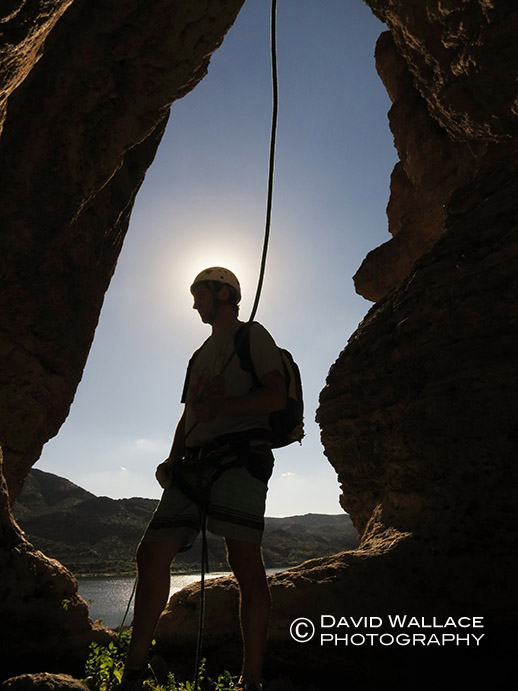
The Year, Part III – The lightest of days in Diana’s Throne Canyon

Diana’s Throne Canyon, 3AI
BLM land east of Zion National Park
3/26/17
.
To keep this train moving before the engine locks up and it never starts again, here is a quick report, of a quick descent from over a year ago. It was however part of the narrative of The Year, that year being 2017, for those keeping track.
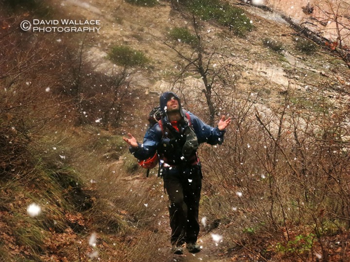
After the terrifying descent down Behunin Canyon, the day before the group was looking for something light before heading home. Diana’s Throne Canyon, aka Huntress Slot, aka Elkhart Cliffs Canyon, aka Diana’s Canyon, seemed to fit the bill. It did and with the weather a complete 180 from the day before we got our muscles moving in the canyon lands for a few hours of fun in a charming and novice slot before the long drive home.
Next up a return to Climax (for whenever that may be).
-David
-

- Eric and Mark in a charming section of the slot.
-

- Brian handlines down a short drop.
-

- Eric
-

- Pat looking up and what I believe was an owl’s nest.
-

- The short and simple exit hike.
The Year, Part II – A threat to the Grand Canyon
The forecast has looked awful all week. This is never a good thing when heading into the canyon lands. You may have gotten a sense of this when reading my last post, but for this excursion it was for an entirely different reason than the fear of a flash flood. Despite the forecast, I am joined by Grand Canyon explorer Rich Rudow into the remote western part of the Grand Canyon on an Arizona Republic/ azcentral.com reporting trip to visually document the hundreds of helicopter flights per day that leave from Las Vegas. They offer tourists a chance to fly into the canyon along the Colorado River and get back to the slot machines in a matter of hours. With the rain and wind however in the forecast would the Las Vegas tourists choose to see Penn and Teller instead? Would the tour operators even still fly? For me it’s a long way to travel to document what the activists are calling “Good Morning Vietnam” if all the helicopters are grounded.

After a 10- hour drive, followed by an all day off trail hike, dropping nearly 5,000 vertical feet through multiple layers of geology I hear my first helicopter. Clouds fill the sky but the ground remains dry. We reach the river and set up camp. Helicopters buzz over head around every 15 minutes. Rich comments that the volume is down. He thinks because of the weather. Until now the skies have stayed dry but halfway through my chicken and dumplings Mountain House the weather begins.

The rains come in heavy and quickly. We haven’t seen a helicopter in 20 minutes and I assume the popular sunset tours have been cancelled because of the storm. Just then I can hear the drone of rotors approaching. A pair fly directly over the river and land on the opposing bank a quarter mile upstream. As I’m being hammered by rain I shoot stills and video of the helicopters. Night begins to close in and the helicopters remain grounded. Red and white lights flashing on their tails can be made out through the thick atmosphere. “I think they’ve found themselves fucked out there,” Rich comments besides me. He elaborates, they are not supposed to be here after dark but the weather may be preventing them from getting out. The winds bring them good fortune and they die down slightly as do the rains. Just before full dark they take off and head back to the lights of Sin City.

We retire to Rich’s tents and go horizontal. While sharing in the pleasant chit chat of adventures past I notice a warm glow illuminating the walls of the tent. I race outside to see the most amazing Grand Canyon sunset I’ve ever seen. The light show of the Fountains of Bellagio have got nothing on this.

The following morning, less than an hour after sunrise the noise can be heard before they can be seen. Its a striking juxtaposition to this wild and remote place. Then they start coming one after another and that pristine essence is shattered. Rich and I spend the better part of the day walking along the river documenting chopper after chopper. Some claim it is the busiest helicopter corridor in the world. Though I can’t verify this it wouldn’t surprise me. Long after losing count on the actual number, Rich and I begin the long trek back to the rim. The following morning I have a rendezvous with friends for another nearby adventure. The rain didn’t stop the helicopters, but as you may already know it will stop this one, only creating a different one.
-David
Check out the story on azcentral.com.


The Year, Part I – The road and a terrifying descent in Behunin Canyon
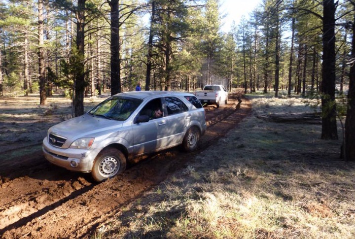
“We awake at first light to a truck honking its horn. “We need to get out of here and start the drive while the roads are still frozen!” It is Brian, “It gets sloppy just ahead!” We grab our stuff and are off in moments. We soon encounter the stickiest mud we’ve ever dealt with. Stopping to try and clean off our tires is futile. Slowly we continue, fish tailing here and there. With about 10 miles to go to the trailhead the road enters a ponderosa pine forest and things go south very quickly. It takes only minutes for my aging 4×4 Kia Sorento to get trapped into a shin deep rut in this mud. We spend the next hour and a half rigging up tow ropes to Brian’s truck to retreat the quarter mile we had come into the pine forest. With our tails tucked between our legs we are now heading away from our long awaited canyoneering destination, Climax Canyon, but we are relieved, not to be stranded 80 miles from the nearest paved road. ” – Eric Luth

A year unfolds. Work, family, adventure. Sometimes individual events within a year bridge to each other telling a connected narrative deeper than the individual parts. So it was in 2017. The story begins above with Eric’s tale of the road. I was not there. I was 10 miles away, already three days into the adventure awaiting their arrival. As indicated they never made the rendezvous, but more on that later. This story will also end on this same road, seven months later. That will also be coming. For now lets get back to Eric.
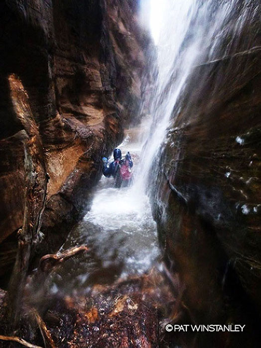
“The rain starts to come down again, this time a little harder. I wait patiently just watching it go from a drizzle to a steady shower. I know the only way out is through the canyon now. Pat and I are moving quickly though a narrow hallway with towering cliffs on each side. The rest of our group of five is a little ways ahead. We soon come to a sight that even though it was my first time though this canyon, I knew didn’t belong there. From hundreds of feet above a falling cascade of water is pouring into our canyon at an alarming rate. I turn to Pat with a serious glare, “We need to get out of here!” No response was needed and we fly under and through that waterfall into deeper pools, which are typically bone dry. Not more than five minutes down canyon we catch up to the rest of the group; wide eyes all around.” – Eric Luth

Behunin Canyon, 3CIIIR (normally 3BIII)
Zion National Park
3/25/17
.
I was also not present for Eric and Pat’s terrifying moment in the hallway. I was just a few hundred yards ahead, in the front of the pack of our group of five. As I wait for the rest of the group to catch up I’m watching both rain and flows pick up in what should be a near bone dry canyon. “Why the fuck did I get myself into this situation?” I think to myself. I just want the next person in the group to join me so I can stare into their eyes and share this fear and loathing.
It hasn’t started flashing yet but it seems like that beast could be released from its cage at any moment. Just around the corner is high ground that would be just out of the grasp of even the biggest and baddest beasts of them all, but this is still deep in the narrows. Its late in the day, and the thought of an overnight bivouac seems almost as terrifying as the beast itself in these frigid temperatures. I stand on my high ground, the taste of acid in my mouth as I can’t get that thought out of my head “What did I get myself into?”

30 hours earlier –
We arrive a half hour early to the rendezvous point on the rim of the Big Ditch deep in the wilderness. Alongside me is, Grand Canyon explorer and activist, Rich Rudow. I’ve just finished a 3 day adventure/ reporting trip (that story in Part II) with Rich as I await my companions to begin a 4 day backpacking/ canyoneering adventure. It’s as if Rich is a divorced parent about to hand off their child to their ex for the weekend, except Rich is way more patient than the analogy suggests. I’m starting to getting nervous as I watch the intense Arizona sun slowly turn the frozen dirt road to slop. An hour after the meet up time I say to Rich I don’t think they’re coming. We starting heading out in Rich’s off road capable vehicle to find them and possibly rescue them from the road.
The road is only getting worse and then after 10 miles I see the tire tracks, nearly three feet deep. It must be them, but their vehicles are no where in sight. Another hour and the road begins to improve. Then we see them, waiting, their vehicles caked in mud. Rich makes the exchange and heads his own way. Eric, Brian, Pat, Mark and I discuss an alternative adventure. Zion National Park is just a few hours away and completely on paved roads.
The following day the forecast is not good. The temperatures frigid. Our options in these conditions are extremely limited. Behunin Canyon, a relatively small drainage that is normally bone dry seems to fit the bill. With the forecast suggesting an improvement in the afternoon we get a late start. The approach begins in the rain and turns to snow as we gain elevation, but we haven’t committed ourselves, so we continue. When we get to the saddle above the drainage the precipitation relents and we drop into the drainage. Along the way a massive tree branch falls just feet away from from Mark. Had he been any closer it could have been a lethal strike. Perhaps, a bad omen for the day, but we haven’t committed ourselves, so we continue. When we get down to the drainage it is lightly flowing but the rain and snow have stopped, so we continue. We get to the first rappel, the point of commitment. The rain has not returned as the weather forecast indicated it might do. We continue. An hour later I’m waiting deep down inside dark narrows for both my friends to catch up and the flash flood to begin.

Once the group joins me on my island of high ground; a mound of sand and dirt covered in trees 20 feet above the canyon floor. Eric and Pat seem especially concerned. Perhaps they saw something the rest of us didn’t. Despite the concern we stay calm and rationally discuss our options. We determine that in these temperatures an overnight bivouac is only a last resort. However, if we are going to make it out before dark then we can’t wait around too much longer. Unfortunately, for now waiting is our only option to determine if the beast will in fact rear its ugly head. After 15 minutes, the rain settles a little, the canyon still has not flashed and maybe the flows have even subsided just ever so slightly. We have a quick conversation and decide to continue down canyon placing ourselves back in the risk of a flash, but moving closer to our ultimate safety. We are making good time in the obstacles until the final rappel sequence, a two stager right in the flow that will spit us out of this nightmare. I’m the first to go on the first rappel and the last to go on the final rappel. During this time I’m observing the water get bigger and bigger as night is creeping in. Still the beast is a no show and after nearly an hour of dealing with this final sequence we are all out of harms way with less than 20 minutes of light to spare. With this adventure in the rear view mirror I would be lying if I didn’t say I was experiencing an incredible feeling of euphoria and vitality that one doesn’t feel often in this life. Having said that I know that the descent itself was one of irresponsibility and we probably got away with one.
In Part II, an adventure of more responsibility and shining light on darkness.
-David
CLICK ON IMAGE BELOW TO BEGIN GALLERY.


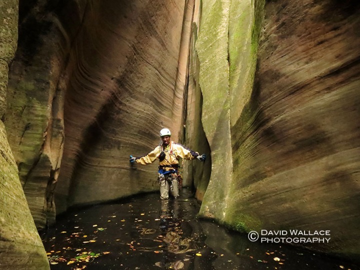
Odds and ends in Blue Pools and Boulderfest Canyons

Canyoneering can be intense, multi-day and on occasion can quickly become epic. Other times it just is a way to relax and spend a portion of the day with a litter of water and some rope and relaxing in some narrow places. These types of adventures don’t leave behind much to say about them but they still enrich your soul. With 2016 faded into history and the arrival of 2017 I thought it would be a good time to dust off some odds and ends of two half day adventures of the past year, where not much happened. That was what was so nice about them.
Blue Pool Canyon 3AI
Lake Powell area
June 2016
.
After an intense all day adventure descending Checkerboard Canyon in Zion National Park the day before all I had in store for this day was the seven hour drive back to Phoenix. To break up the drive I decided for a quick solo descent down Blue Pool Canyon. I had spotted this slot while driving over it on U.S. Route 89 en route to other canyoneering adventures in southern Utah. It had always looked enticing at 60mph so for the first time instead of driving over it I pull off into a sandy parking area, gear up and head under the bridge. A few easy drops, a few photos and a little bit of walking and the slot opens up. I navigate my way out of the canyon into the sandstone world above and back to the highway, enjoying the quiet, solitude and exercise before the remainder of my drive home.
Boulderfest Canyon 3AII
Superstition Wilderness Area
10/25/16
.
When one of my closest childhood friends was in town visiting, as the host I was charged with the task of filling our days with activities; being the camp director so to speak. Like Blue Pool Canyon, Boulderfest Canyon, had always been on my mind from the dozens of times I would look at it while driving past Canyon Lake en route to other adventures. I knew a descent would take no more than 2/3 of a day with driving, the weather was agreeable and I thought Seth would get a kick out of the packraft across the lake, assuming we did get killed by a powerboat driving over us. The packraft was unremarkable under a hot Autumn Arizona sun. It did requires some muscle to make it across but we got there. Even more challenging was deflating out boats with no flat shoreline. Up and over a saddle and down the other side and we were in Boulderfest. You could see the lake for the entire descent. Seth faced his fear, managed the rappels and down climbs and rather quickly we were re-inflating our boats for the float home, or at least back to our vehicles. Seth and I were back home, showered and in time for a 7pm dinner reservation.
CLICK ON IMAGE BELOW TO BEGIN GALLERY.


Virtual Reality in Punchbowl Canyon

David holds the two GoPro Virtual Reality rig while planning out a shot in Punchbowl Canyon.
LOOK BELOW TO WATH THE CANYONEERING 360 DEGREE VIRTUAL REALITY PIECE.
.
Punchbowl Canyon, 3BIV
Tonto National Forest – Superstition Wilderness Area
12/4/16
.
“This fuc*ing camera!,” I mutter to myself as I’m fumbling with two modified GoPro cameras on a rig so their backs are butted against each other and the lenses face 180 degrees apart. Once I get the shot I want laid out and get both cameras recording, I begin floundering with my two sets of lavalier microphones connected to an audio recorder via a wireless receiver. I am deep in a cold, wet slot canyon in the Superstition Mountains of central Arizona. I clap my hands several times loudly to sync the two GoPro cameras and audio recordings. I then yell “Action!” at the top of my lungs. Moments later Eric comes down a 120- foot rappel into a narrow hallway above me, as down canyon, Mike, Laura and Susan make their way across a frigid slimy pool of water. I stand somewhere in the middle watching all the action. The cameras record it all between narrow walls. This my first foray into 360 degree Virtual Reality video. A few months earlier several USA Today video producers asked if I could shoot a Virtual Reality video for them on canyoneering. Always eager to play and learn new technology and even more so, to get paid to go canyoneering, I jumped on the opportunity. After assembling a crew and picking a date we are out on the trailhead on a cold December morning. It was a canyon that our group of six had all done and were familiar with. In the past a descent of this canyon had taken as little as six hours. I knew today would take much longer.

A frame grab from the 360 degree Virtual Reality video in Punchbowl Canyon.
As the day progresses and shots are produced it becomes clear that battery life becomes my most precious commodity. As I push blinking battery bar indicators to their fullest I do my best to dot every “i” and cross every “t” while trying to record compelling 360 degree footage of this stunning, rugged and challenging desert slot. The hardest part of shooting VR is 360 degrees means everything around, above and below you is part of the footage. Making choices of what to include and what not to include becomes much more challenging than with traditional videography and photography. Combine this with the aforementioned clunky operation of the equipment in this hostile environment and let’s just say it wasn’t that typical day of canyoneering. Four hours past when we would have been to our vehicles on a normal descent and night is not far around the corner, but the last rappel is still at least an hour away. In the end we make that final rappel and much needed closing shot just before dusk. My crew was extremely patient despite the seemingly excessive production and time in these raw conditions. Kudos and much thanks to them. So without further chronicling let me present to you the finished video piece below. Since virtual reality video is a relatively new medium I have included a list of tips to help you better enjoy the experience.
-David
- The canyoneering segment starts at the 1 minute 38 second mark.
- It doesn’t work on the Safari web browser on either desktop or mobile. I suggest Chrome on desktop or the YouTube app on your phone.
- You need good bandwidth or the resolution will not be good and will make for a nauseating viewing experience.
- The best way to view is with your phone and a Virtual Reality headset but since most people don’t have headsets I still think with your phone is better than desktop so you can move the phone around and see full 360 degrees. On desktop use your mouse to navigate around 360 degrees.
- You really have to navigate around to see everything that is going on. You may have to watch the video more than once to do that. Try using a swivel office chair.
- I didn’t have anything to do with the title which I think is a little misleading and happens to be the same as Todd Martin’s book on canyoneering in the Grand Canyon.
Check out USA Today’s VR Youtube channel VRtually There.
Into the vastness: Kanab Creek

It’s been two months since I finally sit down to chronicle this trip. Much has happened since then. A presidential election shocked almost everybody, leaving those both in support and opposed to the President elect, unsure of what to expect. Through the uncertainty, the holiday front moved in, along with cooler weather. Throw on top of that relentless work and the obligations and joys of parenthood and those brisk details of this most recent adventure have fogged. One experience from this trip, however, stays well solidified in my consciousness and that is the notion of vastness. Though far from the first time participating in a multi-day adventure exploring the enormity that is the Grand Canyon, this trip really seemed to showcase that epic and stretched out land at an unparalleled level. Even before our soles touched this Earth it was big. On the drive to the rim, pavement over 30 miles back, we could sense the expanse in the darkness. The road ends on the edge of the rim, nothing but air in front of us. As we roll out our sleeping bags we wonder where the New Mexico and Colorado contingent of our crew are. We were supposed to rendezvous nearly 20 miles ago. They were not at the designated spot. Too much space and darkness to find them so we drove till we could drive no further, hoping they would do the same. I close my eyes looking forward to seeing what I already feel about this space and hoping the rest of the crew shows.

First light and a fresh pair of daily use contacts do indeed illuminate the hugeness of this place. Just 30 feet away the world drops into a sprawling complex; a massive multi-tiered canyon stretching for many miles in multiple directions. It is a canyon of epic scale, but it is also nothing more than a single side canyon; one of hundreds of adjoining drainages of the main corridor of the Colorado River’s Grand Canyon. It may be only a side canyon, but it is one of the Grand’s biggest. It is Kanab Creek. A side canyon so big that it has several dozen of it’s own side drainages. Kanab Creek is so extensive in its own right that we can not even see the inner corridor of the Grand Canyon from our current perch. All we see is the Kanab Creek system. Before I have time to really take in the view I can hear a vehicle approaching and within minutes our Colorado and New Mexico contingent arrive. Final packing is completed and we hit the trail to see what is lurking down below in this massive place.

Kanab Zero, 3BVI
Grand Canyon National Park
10/28/16
.
A game of chutes and ladders begins and we try to find a way past several cliff bands to get to the layer that will grant us passage to our side canyon du jour, Kanab Zero. Undulating up and down we slowly traverse further and further away from Kanab Zero. We eventually give up on a walk down past the Coconino cliff band and break out the rope to set up a rappel. Once down to the Esplanade we work our way back to “Zero” and finally into it’s clutches. We approach the edge of the Supai, a last dance with vastness before dropping into the labyrinth of the Kanab Creek system. What ensues is a sphincter puckering 400- foot, two stage rappel. Shortly after hitting terra firma the Redwall closes in and the real fun begins.

Rope and rappels, pools and swims, rain and sun, all within a world of polished white rock intermittently stained iron red. The scale of the place that we are deep within is becoming a distant memory as these walls are narrow and the views reveal only the beauty right before us. Eventually everything before the here and now fades away as the canyon’s aggressive technical characteristics keep us locked into the current moment and space. “Zero” is rather insignificant on the map; a short stretch before hitting Kanab Creek proper, but in this place distance and time don’t correlate. It’s consecutive rappels, almost all of which are of considerable height are eating up much of the day. Eventually we hear the sounds of Kanab Creek in the distance. A final drop brings our soles into the flowing water as dusk approaches. A short jaunt downstream and we set up camp on a creekside limestone bench.

Whispering Falls Canyon, (sneak route) 3BVI
Grand Canyon National Park
10/29/16
Another side canyon of Kanab Creek lurks just around a bend. To descend it we must first gain a level and traverse around to where we can drop in above these technical highlights. This route requires ascending a gully of rotten rock before traversing a narrow and exposed bench 500 feet off the desk. It is sketchy and exciting and then once in Whispering Falls canyon, the kosher fun can begin. Several obstacles present themselves but this half day adventure is all about the final crux rappel, a beauty of a drop down a spring fed chute which whispers “you are here,” over and over again in hushed tones. The whispering waterfall transitions into an exquisite hallway followed by a pool of turquoise water. Not long after and we are back to Kanab Creek and the long haul upstream through massive boulders, a prickly pear forest and numerous pools; a true slogfest through Water and Earth. The soles of Eric’s shoes become a casualty of the conditions and we are many steps into this place. By the time we hit the confluence with Scotty’s Hollow Eric has figured out to work his disabled shoes.

Scotty’s Hollow, (ascent) 3BVI
Grand Canyon National Park
10/29/16
.
In just over 30 hours we have seen and experienced a tremendous landscape both from above and within. We have worked our bodies hard to do so. Now to get out of this place we must push them harder. We quickly realize our ticket out of here will reveal a space of unique and unparalleled beauty, but the up-climb obstacles will require skin, athleticism and teamwork. They are numerous and they seem to get ever more challenging the further up we climb. The walls close in as the water flows down, the combination making the obstacles ever more challenging. I monitor the rim of the Redwall to watch it get lower the higher we climb, 300 feet, 200 feet, actually it might only be 150 feet and so on. Just when I think we are out another obstacle presents itself, until we are out for real. We find a sandstone bench for camp. We are out of the subterranean world and back into the vastness. Our day once again pushed nearly to dusk. We are exhausted and very content. We are treated to a magnificent sunset as the JetBoil is passed around.

.
From camp we can see our exit out of the Kanab Creek system to the rim above. It is big and imposing, three thousand feet of vertical through multiple sections that seem impassable. We are hoping proximity will reveal the path. First we must escape the Supai, a task in itself. We use a side drainage of Scotty’s. Perhaps a mistake but it does go after several exposed and technical moves. We then must circumvent the system to the route that will take us through the upper layers of the canyon. Once this is accomplished the real vertical attack begins. We find a good use trail that makes progress as efficient as possible. Teamwork is no longer required. It’s just put one foot in front of the other and breath. We find our rhythms and organically break into sub groups or go solo. As the path disintegrates more chutes and ladders are required through those sections that appeared impassable from below. It is challenging and sketchy but we find our way. Eventually Pat and I top out on the rim. We wait for the others. We say little and I don’t think about much. I am just here sitting on dirt, next to my backpack, right on the edge of the immensity. It feels good.
-David
CLICK ON IMAGE BELOW TO BEGIN GALLERY.


Too long since canyoneering on the Mogollon Rim – Immaculate Canyon

Immaculate Canyon, 3BIII
Coconino National Forest, tributary of West Fork of Oak Creek
08/14/16
.
It has been too long since experiencing this place between narrow walls. It was October 22, 2012, in fact, when Eric and I made a beautiful autumn descent of Barney Spring Canyon. This was the last time I descended a technical canyon on the Mogollon Rim. Over 8- years ago, in these sandstone slots hidden in this 200- mile long escarpment I fell in love with canyoneering. In 2012, around the same time that I last got on rope on the Mogollon Rim, Mark and Brian made a first descent of a canyon just next door to Barney Spring Canyon. They were in fact searching for a canyon posted by canyon guru Tom Jones called “Obfuscation Canyon”. It was posted with not much more than a few dramatic photos and a “Flagstaff, Arizona” location tag. Brian should have looked up the definition of obfuscation first, but he was on the hunt for canyons in the Flagstaff area. Instead of finding what he was looking for, he found and pioneered a first descent of a canyon that might just be better. Four years later Mark was back for the first time since that first descent, and I was back for my first time in too long in this magical place.
We begin the descent on a muggy, bug infested, Sunday morning. I am not feeling my best after a late night of too many Red Bull and vodkas while making an extended appearance at friend and fellow canyoneers, Chris Ngo’s party to christen his magnificent new pool. The party adding an hour’s drive was well worth it, but got us in late and starting the canyon a little off kilter as we negotiate thick vegetation making our way into the canyon. The dirty approach is short and the first drop comes in quick. As rope slides through my hands and device, my feet gingerly scamper down the vertical electric green moss covered walls. The magic of this place washes over me and the bugs, humidity and hangover disappear. Challenging rappel situations ensue requiring good technique to avoid sticking ropes and managing multi-pitch. “What a find!” I comment to Mark.

The canyon relents and we make use of a recently publicized sneak exit that allows us to escape from the West Fork of Oak Creek Canyon complex just minutes from the last rappel. It will save us hours and miles not having to circumvent around the entire system. The sneak is dirty and steep. Signs of the 2014 Slide Fire are everywhere with charred trees lined like burnt matchsticks overlooking the rim in all directions. It is slow going but direct and in under an hour we top out on the rim. We move through the remains of trees that stand over a carpet of green growing out of the scorched earth. The burned over area ends and we are back into the shade of the untouched Ponderosa Pines. Hello my old friends. Good to see you again. It is not that I haven’t spent time in the last four years on the Mogollon Rim or in Arizona’s massive Ponderosa Pine forest. To the contrary I have done numerous hikes and camping trips in this magical place in the last four years. For some reason it feels a little different walking under these trees after completing a canyon descent in the hidden slots below these majestic sentinels. Like I said before, it has been too long.
– David
CLICK ON IMAGE BELOW TO BEGIN GALLERY.


Checkerboard Canyon, a wild gem in an ever busier place

Checkerboard Canyon, 3BIV
Zion National Park
June 2016
.
First a warning. I let too much time get in the way before sitting down and writing about our late Spring descent of Checkerboard Canyon in Zion National Park, so a detailed cohesive report might be a bit lacking. Though easier than Heaps or Imlay, Checkerboard Canyon has the feel of a rugged, remote and wild canyon far removed from the hordes that descend the jeweled trade routes glimmering on the canyoneering crown of Zion National Park. If you want a detailed report you can easily find one out there but this won’t be it. Included are a few gems that cut through my memory fogged from rearing 3 children, too many hours working outdoors in the hot Arizona sun and too many after work cocktails.
Checkerboard eluded us last Fall when weather made a descent out of the question. I wasn’t going to miss it this time around, but 48 hours away from home was about all the time I had. This includes 14 hours of driving and around 12 hours for the descent itself. Driving solo and trying to make time I let my speed get the better of me and I’m pulled over east of Kanab by the Utah Highway Patrol. The trooper can not be nicer and lets me off with a warning, but not before he asks me about what are my canyoneering plans for the weekend. He tells me he has never descended Checkerboard. Needless to say my weekend could have easily gotten off on a worse foot had it been for a different cop.

Upon arriving the rest of the crew is already established at Zion Ponderosa Ranch Resort. It is more crowded than I’ve ever seen it. We awake before sunrise in preparation for the long day. The dozens of other campers still sleeping. The journey begins on the long approach along Dakota Ridge. As expected we have this part of the park all to ourselves. Though only a few miles as the crow flies away from Zion Ponderosa Ranch it feels a world away from the zip-line, swimming pool, ATVs and drunk campers. Ironically, we may have been some of those drunken campers last night but on this morning we are all business as we march efficiently across Dakota Ridge.
After a several hour approach the canyon begins in dramatic fashion and never really lets up. Some rather tough down climbs, tight squeezes, diagonal walls and awkward start rappels which are far more characteristic of points Utah east than normally found in Zion, are rather common in this canyon. Cold water comes in and so do humping frogs. Narrows are sustained and the canyon ends with a unique rappel dumping us just above the confluence with the North Fork of the Virgin River.

Spring run-off is still a factor and we are able to body kayak down some of the deeper sections of water. The higher flows and the fact that it is late in the day are keeping the crowds out of this normally busy place. We not only have Big Spring to ourselves but don’t see a single other person until we are just upstream of Imlay Rock. Soon as we get downstream of Orderville Junction the crowds explode. It is an international sea of humanity. I have never seen this many people in the Narrows in over half a dozen visits. Though it is wonderful to see so many people from all across the world connecting with this magnificent place it also brings up notions of ‘loving your park to death’. We reach the shuttle stop to find a line of people backed up well over a 100 -yards. The word comes down the line that it will be a 45- minute wait. As we wait I think back on the contrasts of the day. It’s good to know that wild and isolated places still exist in our smaller and more popular national parks. At least for now. It’s been a 100 years. I worry what it will be in another 100. We are on the shuttle in 30- minutes.
– David
-

- The sun comes up during the approach along Dakota Ridge.
-

- Brian fights his way through thick vegetation as we make our way into the Checkerboard drainage.
-

- Mark on the approach.
-

- Cody silhouetted on the first rappel of Checkerboard Canyon.
-

- Cody on the same rappel in the light.
-

- Mike rappels with a fireman’s belay from Eric.
-

- Mike takes in the canyon.
-

- Eric down climbs with a partner assist from David.
-

- Cody and Mark make their way through diagonal walls.
-

- Mark in more diagonal walls.
-

- Cody on one of the many awkward start rappels with the anchor backed up by Eric.
-

- Cody in a nice section of narrows.
-

- David working through the canyon.
-

- Mike gets on rappel as Brian throws the rope down to keep it moving forward.
-

- Mark wading through water.
-

- Eric on a tricky down climb.
-

- Mark makes his way through an open section of canyon where it looks like there was a somewhat recent rockfall.
-

- Mark bridging a section.
-

- Back in the dark narrows Mike wades through water.
-

- Mike clearly enjoying the show of canyon frogs fornicating.
-

- Mark rappels.
-

- Cody neck deep in cold water.
-

- Mike works the canyon.
-

- Cody reaches to exit a pothole.
-

- Eric on the final rappel of the canyon.
-

- Cody makes his way through the crack of the final rappel.
-

- David negotiating white water with nothing more than his body in the Narrows.
-

- The crew at Big Spring on the hike out in the Narrows.
The distant memory of winter in the desert – Upper Romero Canyon
Palisades Canyon, 3CIII
Coronado National Forest – Santa Catalina Mountains
1/17/16
.
SUMMER IS COMING.
Dreaded words here in the Valley of the Sun. It has hit triple digits, fire season has begun and winter in the desert is beginning to feel like a distant memory.
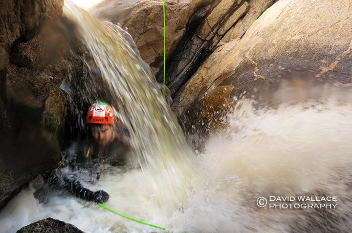
The National Oceanic and Atmospheric Administration was predicting the winter of 2016 to be the strongest El Nino in 18 years dumping abundant and much needed rain in drought stricken California and the southwestern United States. Abundant water in the desert is something special when it happens. Unfortunately, the El Nino never delivered as only a few winter storms materialized leaving far less snow in Arizona’s mountains and canyon country than what many were hoping for. No doubt water managers are looking back on the last six months with disappointment. And they aren’t the only ones. Canyoneers were hoping for a robust winter and spring season of Class C descents. It never really happened. But for me and my partners timing did strike as within a week of the most productive and wide spread storm of the season we descended Upper Romero Canyon in the Santa Catalina Mountains outside of Tucson.

The hike begins from Catalina State Park in that juxtaposed combination of brisk air and intense sun that helps define winter in the desert. We climb higher into the Santa Catalina Mountains. The roar of fast moving water can be heard distantly below in multiple places. The desert is alive and we are venturing to a place where we will become surrounded by that intense and fleeting energy. The nearly five mile hike and two thousand feet of elevation gain not only gets my heart moving but gives my mind time and space to absorb what I know will be a special opportunity.

Into that energy we go and for the others who have been here before they quickly note the way higher flows. Negotiating down climbs, rope and rappels while being pounded by all that water requires focus. The swims feature hydraulics which also require attention to detail. It’s a wild and exciting ride that is experienced by all five senses encapsulated in a bubble of adrenaline: the deafening thunder of water pounding helmets, the taste and smell of agitated water in the desert, the glow of sunlight bouncing off the not so blank canvas of polished white granite and cold water surrounding every square inch of my flesh. I am alive and taking advantage of this time, place and all of this water; in just the same way the desert is. Fast forward four months and it’s all just a distant memory. Again, for both me and the desert.
-David
-

- Eric makes his way into Upper Romero Canyon.
-

- Mark rappels.
-

- Mark swims a pool after getting off rappel.
-

- Mark hands a bag down to Cody to negotiate an obstacle.
-

- Light and shadows in Upper Romero.
-

- Mark makes his way through a hallway of white polished granite.
-

- Eric works his way underneath a waterfall.
-

- Pat rappels.
-

- Eric rappels.
-

- Eric getting off rope past a hydraulic.
-

- Pat rappels.
-

- Pat wades through water.
-

- Mark works his way down an obstacle.
-

- Mark and Pat make their way through a grass field on the short hike from the canyon bottom back to the trail.
A weekend away in the Jug and Campaign Creek
Campaign Creek, 2CI
Tonto National Forest – Superstition Wilderness Area
04/03/16
.
You have read stories of adventure and physical endurance, precarious wilderness situations and hairy navigational predicaments on this blog. Just scroll down and read about David’s epic 4 day, 40 mile, backpack, canyoneering and packrafting journey in the Grand Canyon for one of those heroic tales. This blog post is not that. This blog post is about getting away from home for a couple of nights, eating pizza cooked on a grate under the stars and rolling out of camp at the crack of 11am to hit up one of the most accessible and quite possibly the most wildly popular canyoneering route in Arizona, The Jug. I had not been in a canyon since Hawaii (while pregnant with the twins) about a year earlier so when I got wind of car camping + Jug decent I was in.

The Jug of Salome Creek, 3CII
Tonto National Forest – Salome Wilderness Area
04/02/16
.
The Jug was in perfect conditions for a leisurely afternoon in the natural waterpark. It was a crystal clear day and our rowdy group had the whole place to ourselves. A late night at camp with friends and a quite night’s sleep (read “no babies”) was just the little escape I was craving. Sunday morning Mark, Eric, Susan, Brian and I hiked a pretty little canyon through Campaign Creek before heading home again.
–Laura
-

- Susan and Eric wade through the cattails in the beginning of Salome Jug.
-

- Cattails snowing down on Chris in Salome Jug.
-

- Susan having fun.
-

- Lili enjoying a natural waterside.
-

- Making our way through the canyon.
-

- Laura loving the canyon.
-

- Susan in the Jug.
-

- Eric headfirst.
-

- Sang on rappel.
-

- Chris exits the canyon.
-

- Brian in the Jug.
-

- The view from camp.
-

- Campaign Creek
-

- The final pretty little section of Campaign Creek.
-

- Campaign Creek
-

- Campaign Creek
-

- Campaign Creek
-

- Eric emerging from a boulder cave.
-

- Mark showing off some skills in Campaign Creek.
-

- A little waterfall in Campaign Creek.
-

- Campaign Creek
-

- Susan and Eric in Campaign Creek.
-

- Brian (from left), me, Eric, Susan and Mark in Campaign Creek


1 comment